Skip past header
USGS logo
bathymetry off Cape Cod
Link to Coastal and Marine Geology Program

Archive of Raw Bottom Photographs Collected During Cruise P1-04-GM, Northern Gulf of Mexico, 21-24 June, 2004

USGS Open-File Report 2004-1285

by John Evans, Dan Fornari, Lauren Gilbert, Mike Boyle, Jennifer Dougherty, and Deborah R. Hutchinson


2005


Introduction  /   Acknowledgments  /   Equipment and Ship  /   Directories  /   References Cited  /   Technical Requirements  /   Disclaimer  /   Accessibility

Introduction

Click on figures below for larger image.

Figure 1. Cruise Location in the northern Gulf of Mexico.
Figure 1. Cruise Location in the northern Gulf of Mexico. The map shows the cruise track of the Pelican from Point Cocodrie, LA, to the work site in the Mississippi Canyon, labeled Atwater Valley because of its location near lease blocks Atwater Valley 13 and 14.

Figure 2. Cruise tracks showing camera tows (bold lines) and EM profiles (light lines).
Figure 2. Cruise tracks showing camera tows (bold lines)and EM profiles (light lines). Color coding for the camera tows is: tow 1 - black; tow 2 - red; tow 4 - blue; and tow 5 - green. Mound f coincides with the confluence of tracks in the lower right; mound d coincides with the confluence of tracks in the upper left of this figure.

Figure 3.  R/V Pelican (courtesy of LUMCON).
Figure 3. R/V Pelican (courtesy of LUMCON).

Figure 4.  Schematic of TowCam, side view
Figure 4.Schematic of TowCam, side view.

Figure 5.  Photo of TowCam, side view.
Figure 5. Photo of TowCam, side view.

Figure 6.  Schematic of TowCam, top view.
Figure 6. Schematic of TowCam, top view.

Figure 7.  Photo of TowCam, top view.
Figure 7. Photo of TowCam, top view.

Figure 8.  Fully rigged TowCam being deployed over the stern of R/V Pelican.
Figure 8. Fully rigged TowCam being deployed over the stern of R/V Pelican. Marshall Swartz, WHOI, is leaning against the TowCam sled; Rob Evans, WHOI, is handling the lines; an unidentified crew member is on the left of the screen. The camera and CTD units are in the upper part of the sled; the battery units sit in orange cases on the bottom of the sled; the yellow vane provides stability during towing.

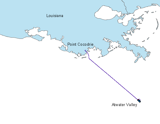
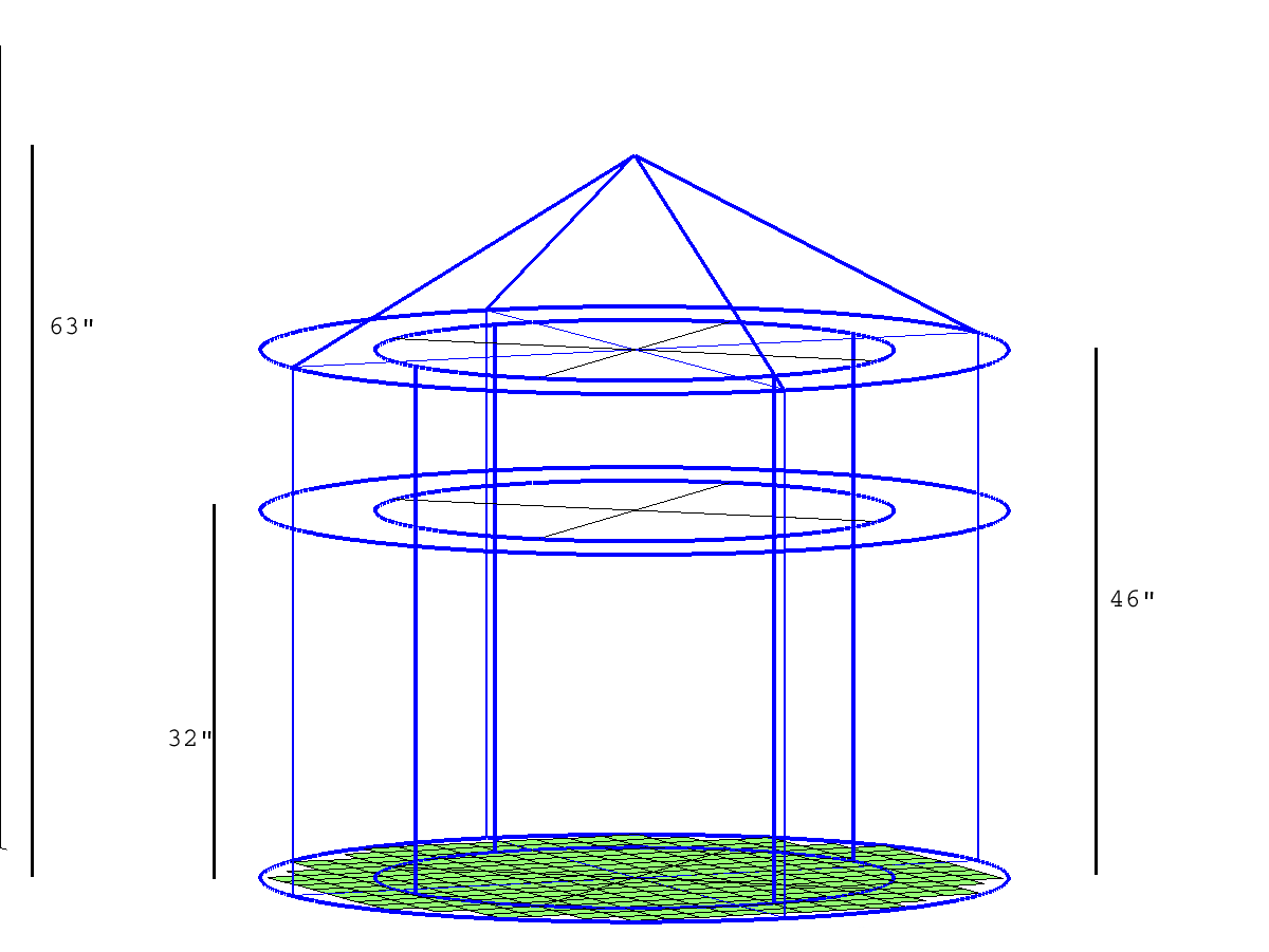
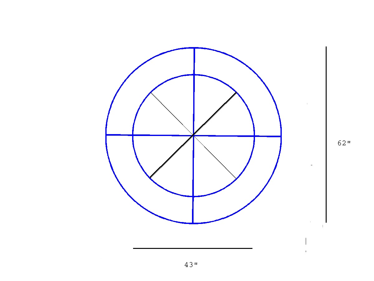
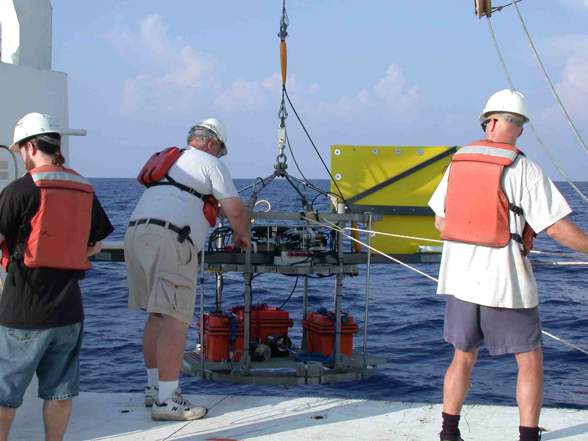
This report is the raw data archive for bottom photographs and related tow-camera data collected in June, 2004, in the northern Gulf of Mexico aboard the research vessel R/V Pelican. The photographic images were collected to evaluate whether chemosynthetic organisms existed on the sea floor in association with two sea-floor mud mounds in 1,300-m water depth on the floor of the Mississippi Canyon near lease block Atwater Valley 14 (Figure 1). These mounds were identified as a potential drilling site for a joint industry-government-academia project in the Gulf of Mexico to study gas hydrate (Jones and others, 2004). Similar to many other mounds in the northern Gulf of Mexico (Sager and others, 2004), these mounds show seismic amplitude bright spots and are probable sites of fluid venting, providing a potentially favorable environment for development of chemosynthetic communities and surficial gas hydrate. Because drilling is not allowed within approximately 300 m of chemosynthetic communities without waivers from the Minerals Management Service (MMS), understanding the distribution of seafloor ecosystems is therefore a necessary part of safety and permitting.

This cruise is known by the designations PE-04-49 (UNOLS), P1-04-GM (USGS InfoBank), and 04021 (USGS Woods Hole Science Center Field Activity Number). The tow camera was deployed 5 times around and between two mud mounds (Figure 2) resulting in 5,973 photographs. Tow 1 was a test tow to determine water clarity and optimal towing height, and did not include all supporting measurements (e.g., layback). Tow 3 was aborted shortly after deployment and provided no useful imagery. This archive therefore contains raw imagery from tow 1 and tow 2 (disk 1) and tows 4 and 5 (disk 2). Interpretations are not part of this report. Subsequent publications are expected to give corrected navigation, image dimensions, interpretations, and other processing improvements for the digital imagery.


Acknowledgments

Funding in support of this cruise was provided by the Department of Energy, the Deep Ocean Exploration Institute of the Woods Hole Oceanographic Institution, and USGS. We thank Elizabeth Pendleton and Dann Blackwood for their thorough reviews, and Donna Newman for her patience and expertise in formatting this publication.


Equipment and Ship

The R/V Pelican is a 35-m-long research vessel operated by the Louisiana Universities Marine CONsortium (LUMCON) out of Cocodrie, LA. It can accommodate a research staff of up to 16, has several labs on board, and a good working deck for equipment deployment and recovery. (Figure 3).

The digital camera is a Nikon 995 Coolpix, 3.3 Mpixel, which records up to 1000 images of 2048x1536 resolution on a 1 GB CompactFlash card. It is part of the WHOI Deep Submergence Towed Digital Camera and MultiRock Coring System (TowCam). The towing sled was built specifically for this cruise on the Pelican (Figures 4-7) and houses the digital camera, a SeaBird25 ctd profiler (including altimeter, depth, conductivity, temperature, and turbidity sensors), strobe lights, and batteries to operate the camera (Figure 8). As configured, this system does not provide the MultiRock Coring System capability. The system utilizes standard UNOLS 0.322" coaxial CTD sea cable for towing from the ship, allowing for real-time monitoring of digital and altitude (and other SeaBird) data for maintaining the camera sled at a uniform height above the sea floor. A more complete description of the camera and system is included in the file towcam_manual.pdf.

The primary navigation system for the cruise was Differential Global Positioning System (DGPS) utilizing USGS YoNav software ( http://walrus.wr.usgs.gov/marfac/software.html) that logs and integrates navigation and other ship data (e.g., water depth) as well as giving vessel steering and tracking services.


Directory Structure

The two DVDs comprising this publication contain files with the raw imagery and supporting data. All supporting data are included on each DVD. The DVDs differ in the included raw imagery; the first DVD has the imagery from tows 1 and 2; the second DVD contains the raw imagery from tows 4 and 5. There were no useful images from tow 3, which was aborted early.

  • docs - This folder contains files that provide additional information about the cruise, the equipment and the data. The cruise report (P1-04-GM_report.pdf) summarizes operational aspects of the cruise. The TowCam manual (towcam_manual.pdf) gives specifications and operations for the digital camera system. The field of view file (DSPL_camera_view.pdf) lists the conversion parameters for estimating the field of view and pixel/m scale from camera altitude.

  • web-galleries - This folder contains 4 folders (for tows 1, 2, 4, and 5) that contain thumbnail and low-resolution images of all the camera images that can be rapidly displayed using an html interface. The imagery for tows 2, 4, and 5 are subdivided into smaller sections because of the large number of images.


    In order to activate the interface, double click on the index.htm file name in each folder, which will activate the internet-browser interface. Note that the first images on most tows are black so that the user will have to scroll forward through the thumbnails to see interesting imagery.

  • imagery - These folders contain the full-resolution, unprocessed, photographic images for tows 1 and 2 (DVD 1) and 4 and 5 (DVD 2). All imagery is in jpeg format. There is a separate folder for each tow. All images are named by date and time in the following format: year_month_day_hour_min_sec.jpg. Each full-resolution image is between 800 and 1000 kbyte in size (2048x1536 pixel resolution).

  • navigation - These files contain the raw navigation collected during the cruise, i.e., the positions recorded for the DGPS antenna on the ship. The antenna was positioned 16.7 m in front of the stern of the ship and 3.3 m to the port of the centerline of the ship. File notations are:
    • *r03, *.r04, *.r05 - raw serial port inputs from the DGPS and compass
    • *.GPS - full, sub-second temporal resolution DGPS files.
    • *.NAV - smoothed versions of the GPS files. The temporal resolution is ten seconds.
    • *.xml - file record of the YoNav navigation set up. P1-04-GM.txt - a log file of all comments manually entered into the YoNav system

    The naming convention is cruiseID-julianday.file_type. Julian Day 172 is June 21, 2004, so that 104-172.NAV is the ten-second resolution navigation file for that day.

  • laybacks: - These files give the estimated distance behind the ship where the camera system was relative to the stern of the ship. Laybacks were calculated assuming a right triangle geometry: the CTD gives depth, the wire out gives the hypotenuse, and distance back is estimated as the third leg of the right triangle. There are two files for each of tows 2, 4, and 5 (layback information was not collected for tow 1, which was a test deployment):
          *.txt gives laybacks in a simple ascii text file.
          *.xls gives laybacks in an excel spreadsheet format.

  • CTD-data - These files contain additional digital data collected from the tow camera. The extensions identify the data type:
    • *.hex - raw data from the SeaBird SBE 25 in hexadecimal format downloaded directly from the instrument.
    • *.CNV - ascii text file produced by SeaBird processing. This file contains a header as well as converted data.
    • *.BL - Bottle Log File
    • *.CON - Configuration file
    • *.txt - The flash *.txt files are produced by the WHOI towcam/ctd processing.

    The flash *.txt files contain fewer data variables and are at general 20 second temporal resolution and correspond to flash events. The text files that did not have "flash" in their names are the complete processed SBE files.

  • postcruise_report - This folder contains the USGS post-cruise report for this cruise.

  • misc - This directory contains photographs taken of the equipment, the ship, and operations during the cruise.

References Cited

Jones, E., 2004, Results of the 2004 Chevron Texaco and others, Gulf of Mexico Gas Hydrate Research Coring Project (abs.), in Collett, T.S., and Johnson, A., Natural Gas Hydrates; Energy Resource Potential and Associated Geologic Hazards: AAPG Hedberg Research Conference. http://www.searchanddiscovery.com/documents/abstracts/2004hedberg_vancouver/short/jones.htm

Sager, W.W., MacDonald, I.R., and Hou, R., 2004, Side-scan sonar imaging of hydrocarbon seeps on the Louisiana continental slope: American Association of Petroleum Geologists Bulletin, v. 88, no. 6, p. 725-746.


Technical Requirements

This DVD-ROM has been produced in accordance with the ISO 9660 Standard and is therefore capable of being read on any computing platform that has appropriate DVD-ROM driver software installed.

The photographs are stored in JPEG format and can therefore be viewed with any number of common image manipulation programs.


Disclaimer:

This DVD-ROM publication was prepared by an agency of the United States Government. Neither the United States Government nor any agency thereof nor any of their employees makes any warranty, expressed or implied, or assumes any legal liability or responsibility for the accuracy, completeness, or usefulness of any information, apparatus, product, or process disclosed in this report or represents that its use would not infringe privately owned rights. Reference therein to any specific commercial product, process, or service by trade name, trademark, manufacturer, or otherwise does not constitute or imply its endorsement, recommendation, or favoring by the United States Government or any agency thereof.

Although all data and software published on this DVD-ROM have been used by the USGS, no warranty, expressed or implied, is made by the USGS as to the accuracy of the data and related materials and (or) the functioning of the software. The act of distribution shall not constitute any such warranty, and no responsibility is assumed by the USGS in the use of these data, software, or related materials.

Information contained within this electronic publication is considered public information and may be distributed or copied, and may not be copyrighted. We request that Public re-use of these materials bear a USGS byline/photo/image credit line.

This disc includes links to internet Web sites. These links will not function unless the user has internet access with an active connection.


Accessibility:

Section 508 and Accessibility at the USGS

The USGS is committed to and is making every possible effort to ensure that all electronic and information technology developed, procured, maintained, or used by the USGS is accessible to people with disabilities, including both employees and the customers we serve.

If you cannot fully access the information on this DVD, please e-mail the contact person or group named in the contact information provided on this DVD, and they will help you. This may include providing the information to you in an alternate format.

For further information and to learn more about the regulations governing the accessibility of Federal electronic information products, visit the Section 508 Web pages listed below:

Section 508 home page - http://www.section508.gov/
Access Board -http://www.access-board.gov/508.htm
Web Accessibility Initiative (WAI) - http://www.w3.org/WAI/


Adobe Reader To view files in PDF format, download free copy of Adobe Reader.


Skip past footer

U.S. Department of Interior
> U.S. Geological Survey > Coastal and Marine Geology Program > USGS Woods Hole Science Center


USGS Privacy Statement and Disclaimer and Accessibility