|
|
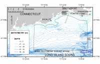 |
| Figure 9. Bathymetry of Bridgeport, Connecticut, study area, bathymetric contours from DiGiacomo-Cohn and others (1998). Click on figure for larger image. |
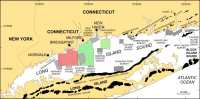 |
| Figure 1. Map showing location of the Bridgeport, Connecticut, study area (red polygon). Click on figure for larger image. |
The shallowest parts of survey H11045 lie along its northern edge where depths are less than 5 m, largely on shoals off Shoal Point and off Stratford Point
(fig. 9). The shoal off Stratford Point has been interpreted to be an ice-marginal glaciolacustrine fan associated with an ice position influenced by the Norwalk Islands moraine, to the west and the Old Saybrook moraine, to the east (Lewis and DiGiacomo-Cohen, 2000) (fig. 1). There is an isolated bathymetric high southeast of Shoal Point fig. 9). Bathymetric variability on these shoals, especially on the shoal off Stratford, is related to the presence of sand waves which range up to 3.5 m high. The sea floor throughout most of the survey area dips relatively gently toward its southern edge where depths are about 35 m. Two depressions are present along the eastern edge of the survey area, adjacent to the Stratford Shoal Middle Ground that is to the east of the Bridgeport Survey. The depressions exceed 50 m and 44 m and mark the entrance to east-west trending troughs that lie just north and south of Stratford Shoal Middle Ground. Constriction of the tidal flow by Stratford Shoal Middle Ground results in increased current speeds within the troughs and environments characterized by erosion or non-deposition. Isolated bathymetric highs, which rise 2-6 m above the surrounding sea floor and lie just west of these depressions, are probably tidal deltas. A bathymetric low in the southwestern part of the survey area is probably related to tidal current constriction within a trough that lies south of a bathymetric high off Norwalk, Connecticut.
Anthropogenic artifacts discernable in the bathymetry of survey H11045 include the Bridgeport Harbor entrance channel fig. 9), which is dredged to over 8 m, and disposal mounds that are part of a discontinued dumping ground located 3-4 km south-southwest of the harbor channel.
|