Other ID: 939009, Phase I Leg A; K-0-69-GM
Status: Completed
Organization(s): USGS, Woods Hole Coastal and Marine Science Center
Funding Program(s):
Principal Investigator(s): Louis E. Garrison
Affiliate Investigator(s): Robert Fedden - NavOceano
Information Specialist(s):
Data Type(s): Location-Elevation: Navigation, Sonar: Single Beam, Seismics: Sparker
Scientific Purpose/Goals:
Vehicle(s):
Start Port/Location: Bayonne
End Port/Location: Corpus Christi, TX
Start Date: 1969-01-22
End Date: 1969-01-28
Equipment Used: Sparker , Echosounder, Loran-C, Seismic reflection
Information to be Derived: Sea floor map; Bathymetric maps; Morphology;
Summary of Activity and Data Gathered:
Staff:
Affiliate Staff:
Notes: Shake down cruise, Leg A, Phase I.
Project = Geologic structures, Gulf of Mexico basin, Geologic structures, Gulf of Mexico basin
test
Foghorn indicates the system used was a sparker.
Location:
northern Gulf of Mexico, United States, North America, North Atlantic;
| Boundaries | |||
|---|---|---|---|
| North: 28.38333 | South: 23.93333 | West: -96.3667 | East: -81.76666 |
Platform(s):
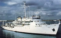 Elisha Kane |
| Survey Equipment | Survey Info | Data Type(s) | Data Collected |
|---|---|---|---|
| Sparker | --- | Sparker | |
| Echosounder | --- | Single Beam | 1969-002-FA-BA-001 (Bathymetric Data on Infobank) NGDC MGD77 data |
| Loran-C | --- | Navigation | 1969-002-FA-LN-001 (Navigation data located at InfoBank) |
| Seismic reflection | --- | Air Gun / Water Gun Boomer Sparker | 1969-002-FA-SE-001 ( Collection of paper record displays of seismic data( SPK) for lines ) |
