Other ID: ASTR 73-JUNJUL
Status: Completed
Organization(s): USGS, Woods Hole Coastal and Marine Science Center
Funding Program(s):
Principal Investigator(s): Charles J. O'Hara, Robert N. Oldale
Affiliate Investigator(s):
Information Specialist(s):
Data Type(s): Location-Elevation: Navigation, Seismics: Boomer
Scientific Purpose/Goals: Uniboom survey of Cape Cod Bay.
Vehicle(s):
Start Port/Location: Woods Hole, MA
End Port/Location: Woods Hole, MA
Start Date: 1973-06-20
End Date: 1973-07-06
Equipment Used: Loran-C, Boomer, Single channel hydrophone
Information to be Derived:
Summary of Activity and Data Gathered: Excellent data were collected along seismic lines spaced one mile apart. Penetration to basement was accomplished in most places. Uniboom lines: 1-25.
Staff: Donald W. McNair, Charles J. O'Hara
Affiliate Staff:
Notes: Project = Massachusetts Co-op, Massachusetts Co-op
Location:
Cape Cod Bay, Massachusetts, United States, North America, North Atlantic,
| Boundaries | |||
|---|---|---|---|
| North: 42 | South: 41.6 | West: -70.6 | East: -70.1 |
Platform(s):
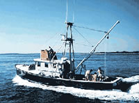
 Asterias |
Oldale, R.N., and O'Hara, C.J., 1990, Maps showing the geology of the inner continental shelf, Cape Cod Bay, Massachusetts: U.S. Geological Survey Miscellaneous Field Studies Map MF-2118, 4 sheets, URL: https://doi.org/10.3133/mf2118.
FAN 1973-004-FA has data viewable in the GeoMappApp/Virtual Ocean applications. To view this data in these applications go to http://www.geomapapp.org/ and http://www.virtualocean.org/. See the instructions for locating USGS data in these applications. You can also view the imagery created from the SEGY data at https://cmgds.marine.usgs.gov/images.php?cruise=1973-004-FA.
| Survey Equipment | Survey Info | Data Type(s) | Data Collected |
|---|---|---|---|
| Loran-C | --- | Navigation | 1973-004-FA-LN-001-01 (Zip archive of Cruise track chart with line numbers, days, and 15-minute positions.
) |
| Boomer | --- | Boomer | |
| Single channel hydrophone | --- | Air Gun / Water Gun Boomer Bubble Gun Sparker Sub Bottom Profiler | 1973-004-FA-SE-001 ( Collection of paper record displays of seismic data( UNI) for lines ) 1973-004-FA-SE-002 (microfilm of LINES 1-32) SEGY data |