Other ID: ASTR 74 DEC
Status: Completed
Organization(s): USGS, Woods Hole Coastal and Marine Science Center
Funding Program(s):
Principal Investigator(s): James M. Robb
Affiliate Investigator(s):
Information Specialist(s):
Data Type(s): Seismics: Boomer
Scientific Purpose/Goals: Uniboom survey.
Vehicle(s):
Start Port/Location:
End Port/Location:
Start Date: 1974-12-02
End Date: 1974-12-03
Equipment Used: Boomer, Single channel hydrophone
Information to be Derived:
Summary of Activity and Data Gathered: Uniboom data: 2 lines (Buzzards Bay Lines 36 and 38).
Staff: Bruce Ambuter, Dennis Edwards, Frank W. Jennings, James M. Robb
Affiliate Staff:
Briggs
Notes:
Location:
Buzzards Bay, Massachusetts, United States, North America, North Atlantic;
| Boundaries | |||
|---|---|---|---|
| North: 41.7 | South: 41.5 | West: -70.7 | East: -70.6 |
Platform(s):
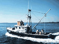
 Asterias |
| Title | Survey Equipment | Description |
|---|---|---|
| Cruise log | (document not focused on specific equipment) | Composite Cruise Log (pdf file) ASTERIAS-Buzzards Bay cruise log containing seismic and navigation entries from October 1-12, 1973(FA 73005); December 2-3,1974 (FA 74017); and June 19-30, 1975 (FA 75011). |
| Survey Equipment | Survey Info | Data Type(s) | Data Collected |
|---|---|---|---|
| Boomer | --- | Boomer | |
| Single channel hydrophone | --- | Air Gun / Water Gun Boomer Bubble Gun Sparker Sub Bottom Profiler | 1974-017-FA-SE-001 (film collection of VNYD SND) 1974-017-FA-SE-003 (microfilm of *SMALL CAN, VIN SOUND) 1974-017-FA-SE-002-01 (Scanned Profiles - 3 scanned record sections in TIFF format.) 1974-017-FA-SE-002-02 (Cropped Scanned Profiles - Cropped images of 3 scanned record sections in TIFF format.) |