Other ID: 75-5
Status: Completed
Organization(s): USGS, Woods Hole Coastal and Marine Science Center
Funding Program(s):
Principal Investigator(s): David W. Folger
Affiliate Investigator(s):
Information Specialist(s):
Data Type(s): Sonar: Sidescan, Sampling: Chemistry, Sampling: Biology, Sampling: Geology, Environmental Data: Temperature, Location-Elevation: Navigation
Scientific Purpose/Goals: The cruise was conducted to make direct observations of geologic, biologic, and hyrologic conditions at three sites where vibracore pipes and railroad wheels had been placed on the bottom as permanent reference markers. All are located in areas where leasing for oil exploration will probably occur. Though the pipes and wheels had been set in June, the specific objective of the dives was to establish geologic and biologic baseline conditions around them. Of primary concern was the magnitude, distribution and character of ripples on the bottom because they indicate, in part, the extent of bottom sediment mobility.
Vehicle(s):
Start Port/Location: Cape May, NJ
End Port/Location: Atlantic City, NJ
Start Date: 1975-08-22
End Date: 1975-08-26
Equipment Used: ORE sidescan, Niskin bottle, Smith-MacIntyre grab, Bathythermograph, Loran-A
Information to be Derived:
Summary of Activity and Data Gathered: Observers on the submarine included USGS personnel and biologists from the Virginia Institute of Marine Science, the Environmental Protection Agency, and the Westinghouse Corporation. Aboard the submarine these observers collected both color and black and white 35 mm photography and video tapes at each site. They also collected sediment samples from specific localities on the bottom. When the submarine was not in the water, other data collected from the ADVANCE II included bathythermograph lowerings, nephelometer lowerings, a series of Niskin bottle casts which resulted in the collection of suspended matter samples, bottom photos, Shipek and Smith-McIntyre grab samples, and sidescan sonar traverses. Dives: 16 (#463-465, 467-479); Sediment samples: 9; BTs: 39; Nephelometer lowerings: 2; Suspended matter samples: 9; Bottom photos: 100; Shipek and Smith-McIntyre grab samples: 13; Sidescan sonar traverses: 3; Color and B/W 35 mm photos; Videos.
Staff: Susan Barton, David W. Folger, Dennis Edwards
Affiliate Staff:
NEKTON BETA pilots: Slater
Zahoran and O'Donnell; VIMS: D. Boesch; EPA: B. Reynolds; Westinghouse: J. Forns
Notes: Original Center People field contained: Dave Folger, D. Edwards, L. Morse, S. Purdy, P. Cousins, and S. Rindge.
Location:
Baltimore Trough, Middle Atlantic continental shelf, United States, North America, North Atlantic;
| Boundaries | |||
|---|---|---|---|
| North: 39.5 | South: 37.4 | West: -75 | East: -72.9 |
Platform(s):
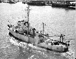 Advance II | 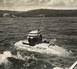 Nekton Beta |
| Title | Survey Equipment | Description |
|---|---|---|
| Cruise report | (document not focused on specific equipment) | Chief Scientist's extensive cruise report describing ship movement, personnel, equipment, data acquisition notes, tape transcription, and map of study area with dive locations marked. |
| Survey Equipment | Survey Info | Data Type(s) | Data Collected |
|---|---|---|---|
| ORE sidescan | --- | Sidescan | 1975-016-FA-SO-001 ( Collection of paper record displays of sidescan sonar data for lines ) 1975-016-FA-SO-002 (microfilm of ) |
| Niskin bottle | --- | Chemistry | |
| Smith-MacIntyre grab | --- | Biology Geology | |
| Bathythermograph | --- | Temperature | |
| Loran-A | --- | Navigation |
