Other ID: ADV2 75-6
Status: Completed
Organization(s): USGS, Woods Hole Coastal and Marine Science Center
Funding Program(s):
Principal Investigator(s): David W. Folger
Affiliate Investigator(s):
Information Specialist(s):
Data Type(s): Imagery: Photo, Sampling: Chemistry, Sampling: Geology, Location-Elevation: Navigation
Scientific Purpose/Goals: The cruise was conducted to make direct observations of geologic, hydrologic, and biologic phenomena at three sites located on Georges Bank. At each of the sites a railroad wheel had been set on a previous cruise. A vibracore pipe was also to have been placed on the bottom prior to the submersible cruise; however, due to mechanical problems the pipes were not set until after the submersible cruise was completed. Of primary concern in the area are the magnitude, characteristics, and distribution of ripple marks on the bottom because these result from both oscillatory and uni-directional current motion. In addition, bottom currents were to be measured directly on the bottom during submersible dives, and distribution patterns and habits of benthic and epibethic fauna assessed. Finally, we hoped to retrieve a string of four current meters that had been set close to one of the diving stations.
Vehicle(s):
Start Port/Location: Gloucester, MA
End Port/Location: Cape May, NJ
Start Date: 1975-09-12
End Date: 1975-09-16
Equipment Used: Camera- deep sea, Niskin bottle, Shipek grab, Loran-A, Loran-C
Information to be Derived: Samples and chemical analysis; Bathymetric maps;
Summary of Activity and Data Gathered: The observations made at three locations on Georges Bank indicate that bottom water flow is intense in the shallow area and probably, during storms, as vigorous in the deeper areas. Thus sediment mobility is probably mostly a function of tidal currents that appear to be capable of eroding or moving sand waves of considerable size. The intensive current regime throughout the whole water column is clearly capable of moving material along the bottom or anywhere in the water column for considerable distances. Thus the vigorous currents may be responsible for significant bottom instability due to the movement of large sand waves. Submersible collected color and black and white 35 mm photography (70 photos) and video tapes at each site. Ship collected 190 black and white bottom photographs taken with a Benthos submersible camera; sediment grab samples: 6; suspended matter samples: 6; bathythermograph profiles: 43.
Staff: Bradford Butman, David W. Folger
Affiliate Staff:
NEKTON BETA pilots: Slater
Zahoran and O'Donnell; J. Farlow (WHOI); L. Minor (Benthos)
Notes: Original Center People field contained: Dave Folger - Ch. Sci., Brad Butman, L. Morse, S. Wieber, D. Geary.
Location:
Georges Bank, United States, North America, North Atlantic,
| Boundaries | |||
|---|---|---|---|
| North: 42.6 | South: 38.9 | West: -74.95 | East: -67.2 |
Platform(s):
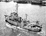 Advance II | 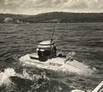 Nekton Beta |
| Title | Survey Equipment | Description |
|---|---|---|
| Cruise report | (document not focused on specific equipment) | Chief Scientist's cruise report describing ship movement, personnel, equipment and data acquisition notes, location map with dive locations. |
| Survey Equipment | Survey Info | Data Type(s) | Data Collected |
|---|---|---|---|
| Camera- deep sea | --- | Photo | |
| Niskin bottle | --- | Chemistry | |
| Shipek grab | --- | Geology | |
| Loran-A | --- | Navigation | |
| Loran-C | --- | Navigation |
