Other ID: ASTR 75-OCT
Status: Completed
Organization(s): USGS, Woods Hole Coastal and Marine Science Center
Funding Program(s):
Principal Investigator(s): Charles J. O'Hara
Affiliate Investigator(s):
Information Specialist(s):
Data Type(s): Seismics: Boomer, Seismics: Air Gun / Water Gun, Seismics: Bubble Gun, Seismics: Sparker, Location-Elevation: Navigation
Scientific Purpose/Goals: Sub-bottom profiling survey of potential mineral resources in Massachusetts coastal waters prior to a coring/sampling cruise. Develop baseline data for environmental impact evaluation prior to resource exploitation.
Vehicle(s):
Start Port/Location: Woods Hole, MA
End Port/Location: Woods Hole, MA
Start Date: 1975-10-17
End Date: 1975-10-30
Equipment Used: EG&G 234, Del Norte hydrophone, Loran-C
Information to be Derived:
Summary of Activity and Data Gathered: A total of 125 nautical miles (231 km) of high-resolution seismic data was obtained with sub-bottom penetration of up to 80 meters.
Staff: Charles J. O'Hara, Robert F. Commeau, Elizabeth Winget, Richard E. Sylwester, Wayne Ferrebee, Patricia Forrestel
Affiliate Staff:
Notes: Original Center People field contained: Chuck O'Hara - Chief Scientist, Dick Sylwester - Electronic Technician, Patricia Forrestel, Wayne Ferrebee, Elizabeth Winget, Robert Commeau.
Project = Massachusetts Co-op, Massachusetts Co-op
Location:
Nantucket Sound, Massachusetts, United States, North America, North Atlantic;
| Boundaries | |||
|---|---|---|---|
| North: 41.75 | South: 41.25 | West: -70.75 | East: -70 |
Platform(s):
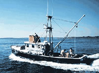
 Asterias |
O'Hara, C.J., and Oldale, R.N., 1987, Maps showing geology, shallow structure, and bedform morphology of Nantucket Sound, Massachusetts: U.S. Geological Survey Miscellaneous Field Studies Map MF-1911, 4 sheets, URL: https://doi.org/10.3133/mf1911.
| Title | Survey Equipment | Description |
|---|---|---|
| Cruise report | (document not focused on specific equipment) | Chief Scientist's cruise report. Lists equipment, personnel, information gathered, and a simple trackline map. |
| Cruise Log Uniboom Seismic | EG&G 234 | Uniboom Cruise Log (pdf file) Composite Uniboom seismic log for Jun. 19 - Jul. 1, 1975, (FA 75011) and Oct. 17-30, 1975, (FA 75024) containing dates, times, navigation, and comments. |
| Survey Equipment | Survey Info | Data Type(s) | Data Collected |
|---|---|---|---|
| EG&G 234 | --- | Boomer | |
| Del Norte hydrophone | --- | Air Gun / Water Gun Boomer Bubble Gun Sparker | 1975-024-FA-SE-001-01 (Line list) 1975-024-FA-SE-001-02 (scanned record sections for lines Lines 1-4, Lines 33-35, Lines 36-39, Lines 40-44) |
| Loran-C | --- | Navigation |