Other ID: 106
Status: Completed
Organization(s): USGS, Woods Hole Coastal and Marine Science Center
Funding Program(s):
Principal Investigator(s): Michael Bothner
Affiliate Investigator(s):
Information Specialist(s):
Data Type(s): Environmental Data: Temperature, Imagery: Photo, Imagery: Video, Location-Elevation: Navigation, Seismics: Sub Bottom Profiler, Sonar: Single Beam, Visual Identification: Submersible Observations
Scientific Purpose/Goals: Investigate the biology and the current and sediment dynamics of Lydonia submarine canyon with the use of the deep diving submersible ALVIN.
Vehicle(s):
Start Port/Location: Woods Hole, MA
End Port/Location: Woods Hole, MA
Start Date: 1980-08-27
End Date: 1980-09-05
Equipment Used: 3.5 kHz, Video camera - deep sea, XBT, Loran-C, Echosounder, Camera- deep sea, Submersible Observation
Information to be Derived: Species representation;Current and sediment dynamics;
Summary of Activity and Data Gathered: ALVIN dives: 9 (#1037-1045, 55 hours 20 min. underwater); Grabs: 37; Cores: 13; Interface sediment samples: 13; Film: 62 rolls.
Staff: Michael Bothner, Bradford Butman, Richard Rendigs
Affiliate Staff:
Richard Slater - Ch. Sci./Geologist
USGS/Univ. CO; Andrew Eliason - ET
Frank Musialowski - sci. asst.; Patricia Gibson - Biologist
Lamont-Doherty; Barbara Hecker - Biologist
Lamont-Doherty; Bob Brown - ALVIN pilot
WHOI; George Ellis - ALVIN pilot
WHOI
Notes: Original Center People field contained: Richard Slater - Ch. Sci./Geologist, USGS/Univ. CO; Mike Bothner - geochemist, Bradford Butman - physical oceanographer, Andrew Eliason - ET, Frank Musialowski - sci. asst., Richard Rendigs - sci. asst.
Project = North Atlantic Project, North Atlantic Project
Location:
Lydonia Canyon, Georges Bank, upper Continental Slope, United States, North America, North Atlantic;
| Boundaries | |||
|---|---|---|---|
| North: 40.56088064 | South: 40.21989765 | West: -67.83835413 | East: -67.47429426 |
Platform(s):
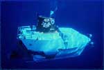 Alvin | 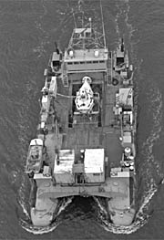 Lulu |
Butman, B., and Moody, J.A., 1984, Bathymetric map of Lydonia Canyon, U.S. Atlantic Outer Continental Shelf: U.S. Geological Survey Miscellaneous Field Studies Map 1710, https://doi.org/10.3133/mf1710.
| Title | Survey Equipment | Description |
|---|---|---|
| Cruise report | (document not focused on specific equipment) | Chief Scientist's cruise report including personnel, equipment, Lulu log of activity, and table of Alvin dives including location, observers, what film was collected. |
| Survey Equipment | Survey Info | Data Type(s) | Data Collected |
|---|---|---|---|
| 3.5 kHz | --- | Sub Bottom Profiler | 1980-023-FA-SE-001 ( Collection of paper record displays of seismic data( 3.5K) for lines ) |
| Video camera - deep sea | --- | Video | |
| XBT | --- | Temperature | 1980-023-FA-OM-002 (Digital tape(s) of BT, NV, CTD STATION DATA, SEA DATA RECORDS, NV-NSTAR-FINAL, ) 1980-023-FA-OM-001 (Digital tape(s) of BT, NV, CTD STATION DATA, SEA DATA RECORDS, NV-NSTAR-FINAL, ) |
| Loran-C | --- | Navigation | 1980-023-FA-LN-001 (Navigation trackline plot for field activity 80023) 1980-023-FA-LN-002-01 (Navigation data recovered from 9 track) |
| Echosounder | --- | Single Beam | 1980-023-FA-BA-001 (Digital tape(s) of BT, NV, CTD STATION DATA, SEA DATA RECORDS, NV-NSTAR-FINAL, ) |
| Camera- deep sea | --- | Photo | |
| Submersible Observation | --- | Submersible Observations |
