Other ID: none
Status: Completed
Organization(s): USGS, Woods Hole Coastal and Marine Science Center
Funding Program(s):
Principal Investigator(s): Page Valentine
Affiliate Investigator(s): R.A. Cooper - National Marine Fisheries Service (NMFS)
Information Specialist(s):
Data Type(s): Imagery: Photo, Imagery: Video, Sampling: Biology, Sampling: Geology, Location-Elevation: Navigation
Scientific Purpose/Goals: Revisit permanent monitoring stations established July - August 1980 on Georges Bank in Lydonia Canyon. Establish 2 new stations in Oceanographer Canyon. Conduct photographic surveys for qualitative and quantitative analysis of megafauna. Collect faunal and substrate samples for pollutant analysis. Collect substrate samples to define infaunal populations and for sediment size analysis.
Vehicle(s):
Start Port/Location:
End Port/Location:
Start Date: 1981-07-10
End Date: 1981-07-21
Equipment Used: Camera- deep sea, Video camera - deep sea, Push corer (wh), Northstar 6000 LORAN-C
Information to be Derived:
Summary of Activity and Data Gathered: JSL Dives 1048-1062 and 1065-1068. Bottom samples: 84; film/video.
Staff: Page Valentine
Affiliate Staff:
NMFS: R.A. Cooper - Chief Scientist
J.R. Uzman
Kenneth Pierce
Andrew Shepard
Roger Clifford; University of New Hampshire: Alan Hulbert
Notes:
Project = Georges Bank and submarine canyon baseline and monitoring studies on oil and gas exploration areas, Georges Bank and submarine canyon baseline and monitoring studies on oil and gas exploration areas
Location:
Georges Bank and canyons, United States, North America, North Atlantic;
| Boundaries | |||
|---|---|---|---|
| North: 40.74355742 | South: 40.49639491 | West: -67.80550169 | East: -67.41819769 |
Platform(s):
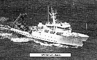 Johnson | 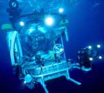 Johnson Sea-link |
| Title | Survey Equipment | Description |
|---|---|---|
| Cruise report | (document not focused on specific equipment) | Chief Scientist's cruise report including personnel, equipment, and station information including location, dive#, water depth, data types collected |
| Survey Equipment | Survey Info | Data Type(s) | Data Collected |
|---|---|---|---|
| Camera- deep sea | --- | Photo | |
| Video camera - deep sea | --- | Video | |
| Push corer (wh) | --- | Biology Geology | 1981-025-FA-SC-001 (SUBMERSIBLE SAMPLE samples) |
| Northstar 6000 LORAN-C | --- | Navigation |
