Other ID: OC104
Status: Completed
Organization(s): USGS, Woods Hole Coastal and Marine Science Center
Funding Program(s):
Principal Investigator(s): Bradford Butman
Affiliate Investigator(s):
Information Specialist(s):
Data Type(s): Environmental Data: CTD, Environmental Data: Temperature, Imagery: Photo, Location-Elevation: Navigation, Sampling: Chemistry, Sampling: Geology, Sonar: Single Beam, Time Series: Mooring (physical oceanography)
Scientific Purpose/Goals: Recover 2 tripods and 4 subsurface moorings. Deploy 2 tripods and 6 subsurface moorings (2 w/ deep instrument package). Set 2 surface marker buoys. Collect surface grab samples at A, Q, and LCA for biology. Deploy and recover experimental water sampling system. Collect surface grab samples around Station K.
Vehicle(s):
Start Port/Location: Woods Hole, MA
End Port/Location: Woods Hole, MA
Start Date: 1981-09-25
End Date: 1981-10-02
Equipment Used: Echosounder, XBT, CTD 19+ with OBS, PAR, DO, Chl, Niskin bottle, Van Veen grab sampler, Camera- deep sea, Loran-C, Bottom platform
Information to be Derived:
Summary of Activity and Data Gathered: Moorings deployed: 10 (#229, 230, 231, 232, 233, 234, 235, 236, and 237, all recovered FA 82001 OCEANUS Jan. 26 - Feb. 4, 1982; and #238 recovered this cruise). Surface buoys deployed: 4 (A,B,O,P). Surface buoys recovered: 2 (R,V). Moorings recovered: 7 (#223, 224, 225, 226, 227, and 228 all deployed FA 81009 OCEANUS 095 Apr. 23 - May 6, 1981; #238 deployed this cruise). CTD stations: 35; XBT stations: 25; Surface salinity samples: 56; Surface grab samples: 58; Bathymetric survey.
Staff: Michael Bothner, Bradford Butman, Mary E. Hastings, John Larson, Carol M. Parmenter, Lawrence Poppe, Richard Rendigs, William J. Strahle, Arnold O. Tanner, Marlene Noble
Affiliate Staff:
Frank Musialowski; Rose Petrecca - WHOI
Notes: Original Center People field contained: Brad Butman, Mike Bothner, John Larson, Frank Musialowski, Marlene Noble, Carol Parmenter, Lawrence Poppe, Richard Rendigs, Mary Polly Shoukimas, William Strahle, Arnold Tanner.
Project = Sediment Dynamics, Sediment Dynamics
Location:
Lydonia Canyon, Georges Bank, United States, North America, North Atlantic;
| Boundaries | |||
|---|---|---|---|
| North: 41.49944 | South: 40.33333 | West: -70.2161 | East: -67.41222 |
Platform(s):
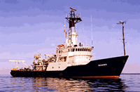
 Oceanus |
Butman, B., 1988, North Atlantic Slope and Canyon Study—Volume 1, Executive summary: U.S. Geological Survey Open-File Report 88-027-A, https://doi.org/10.3133/ofr8827A.
Butman, B., Moody, J.A., and Conley, S.J., 1986, Hydrography of Lydonia Canyon; data report for R/V OCEANUS Cruise 104, September 25-October 2, 1981: U.S. Geological Survey Open-File Report 86-504, 216 p., URL: https://doi.org/10.3133/ofr86504.
| Title | Survey Equipment | Description |
|---|---|---|
| Cruise report | (document not focused on specific equipment) | Chief Scientist's log of ship movement, personnel, equipment and data acquisition notes. Includes maps of mooring locations, sample locations, hydrographic stations, and mooring schematics. Also included is a table of hydrographic station locations and data acquired at each station, as well as the bridge Loran log. |
| Survey Equipment | Survey Info | Data Type(s) | Data Collected |
|---|---|---|---|
| Echosounder | --- | Single Beam | 1981-034-FA-SE-001 ( Collection of paper record displays of seismic data( 12K) for lines ) |
| XBT | --- | Temperature | |
| CTD 19+ with OBS, PAR, DO, Chl | --- | CTD | 1981-034-FA-OM-001 (Digital tape(s) of CTD STATION DATA, ) |
| Niskin bottle | --- | Chemistry | |
| Van Veen grab sampler | --- | Geology | |
| Camera- deep sea | --- | Photo | 1981-034-FA-PH-001 (film collection of TRIPOD 237; 19810926-19820128) |
| Loran-C | --- | Navigation | 1981-034-FA-NL-001 (Logs for XBT/CTD, LORAN C, TECH, MIXED, 12K, ) 1981-034-FA-NL-002 (cruise report) |
| Bottom platform | --- | Mooring (physical oceanography) | 1981-034-FA-OM-002 (Lydonia Canyon mooring data) |