Other ID: none
Status: Completed
Organization(s): USGS, Woods Hole Coastal and Marine Science Center
Funding Program(s):
Principal Investigator(s): Page Valentine
Affiliate Investigator(s): R.A. Cooper, NMFS
Information Specialist(s):
Data Type(s): Imagery: Photo, Imagery: Video, Sampling: Biology, Sampling: Geology, Location-Elevation: Navigation
Scientific Purpose/Goals: (1) Revisit the eight site specific monitoring stations at Lydonia, Oceanographer and Veatch submarine canyons and on the southern flank of Georges Bank for Northeast Monitoring Program studies relating to gas and oil drilling operations; (2) conduct transect surveys to define qualitatively and quantitatively the megafauna of the sea floor and their habitats; (3) collect faunal and substrate samples for contaminant (hydrocarbons, trace metals, and PCBs) analyses; (4) conduct geological studies relating surficial geological and sedimentary features to animal abundance and distribution and describing these features as indicators of bottom current regime; and (5) revisit the deep water monitoring station on the slope east of Oceanographer Canyon.
Vehicle(s):
Start Port/Location: Woods Hole, MA
End Port/Location: Woods Hole, MA
Start Date: 1984-07-02
End Date: 1984-07-12
Equipment Used: Camera- deep sea, Video camera - deep sea, Push corer (wh), Northstar 7000 LORAN-C
Information to be Derived:
Summary of Activity and Data Gathered: Dives JSL2-862 through JSL2-874; 13 stations; 73 sediment samples; film and video employed at all dives.
Staff: Page Valentine
Affiliate Staff:
NMFS: R.A. Cooper
C. Newell
K. Pecci; U. Conn: C. Cooper
P. Auster
Notes:
Project = Project: Georges Bank, Canyons, and Slope Undersea Study of Fishery Resources and Habitats in Oil and Gas Drilling Areas, Project: Georges Bank, Canyons, and Slope Undersea Study of Fishery Resources and Habitats in Oil and Gas Drilling Areas
Location:
Georges Bank;Lydonia, Oceanographer, Heel Tapper, Gilbert, Hydrographer, and Veatch Canyons;Continental Slope, United States, North America, North Atlantic;
| Boundaries | |||
|---|---|---|---|
| North: 40.72482682 | South: 39.98857806 | West: -69.64628943 | East: -67.45179706 |
Platform(s):
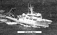 Johnson | 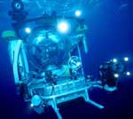 Johnson Sea-link |
| Title | Survey Equipment | Description |
|---|---|---|
| Cruise report | (document not focused on specific equipment) | Chief Scientist's report including personnel, purpose, equipment, tabulation of stations, and map indicating stations. |
| Survey Equipment | Survey Info | Data Type(s) | Data Collected |
|---|---|---|---|
| Camera- deep sea | --- | Photo | |
| Video camera - deep sea | --- | Video | |
| Push corer (wh) | --- | Biology Geology | 1984-007-FA-SC-001 (GRAB, SUBMERSIBLE SAMPLE samples) |
| Northstar 7000 LORAN-C | --- | Navigation |
