Other ID: AST 85-8
Status: Completed
Organization(s): USGS, Woods Hole Coastal and Marine Science Center
Funding Program(s):
Principal Investigator(s): Douglass Owen
Affiliate Investigator(s): Ralph Lewis - CT DEP
Information Specialist(s):
Data Type(s): Seismics: Boomer, Sonar: Sidescan, Seismics: Air Gun / Water Gun, Seismics: Bubble Gun, Seismics: Sparker, Location-Elevation: Navigation
Scientific Purpose/Goals: (1) Define the geology and shallow structure of westernmost Long Island Sound and selected areas in central Long Island Sound; (2) determine the geologic framework and Quaternary development of the area; and (3) identify and map potential geologic hazards.
Vehicle(s):
Start Port/Location: Block Island, RI
End Port/Location: Woods Hole, MA
Start Date: 1985-05-18
End Date: 1985-05-30
Equipment Used: EG&G 234, ORE GeoPulse, Klein 531 sidescan, Innerspace Technology 25-element hydrophone, Loran-C
Information to be Derived: Sea floor map; Morphology;
Summary of Activity and Data Gathered: There were numerous equipment failures and problems during this cruise. However, overall the seismic records are satisfactory. Sidescan sonar was run primarily in the westernmost part of the Sound (a winch is needed in the future). The seismic records were mostly collected using the EG&G Uniboom system with the Benthos streamer. High-resolution seismic profiling: 662.5 km; Sidescan sonar: 404.3 km.
Staff: Douglass Owen, Kenneth F. Parolski
Affiliate Staff:
Ralph Lewis - CT DEP
Ch. Sci.
Notes: Original Center People field contained: Doug Owen; Keneth Parolski - ET.
Project = New England Coastal Geology, New England Coastal Geology
Location:
central and western Long Island Sound, Connecticut, New York, United States, North America, North Atlantic;
| Boundaries | |||
|---|---|---|---|
| North: 41.2 | South: 40.8 | West: -73.9 | East: -72.5 |
Platform(s):
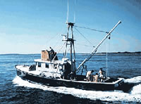
 Asterias |
Poppe, L.J., Paskevich, V.F., Lewis, R.S., and DiGiacomo-Cohen, M.L., 2002, Geological framework data from Long Island Sound, 1981-1990—A digital data release: U.S. Geological Survey Open-File Report 2002-002,
| Title | Survey Equipment | Description |
|---|---|---|
| Cruise report | (document not focused on specific equipment) | Chief Scientist's report including objectives, personnel, equipment, operational procedure, tabulated information, a brief narrative and trackmaps.. |
| Data inventory | (document not focused on specific equipment) | Cruise Curator's inventory of field data items. |
| Navigation log | Loran-C | Loran navigation log containing brief cruise narrative, hourly time delays and notes on course changes. |
| Survey Equipment | Survey Info | Data Type(s) | Data Collected |
|---|---|---|---|
| EG&G 234 | --- | Boomer | |
| ORE GeoPulse | --- | Boomer | |
| Klein 531 sidescan | --- | Sidescan | 1985-016-FA-SO-001 ( Collection of paper record displays of sidescan sonar data for lines ) 1985-016-FA-SO-002 (microfilm of ) |
| Innerspace Technology 25-element hydrophone | --- | Air Gun / Water Gun Boomer Bubble Gun Sparker | 1985-016-FA-SE-003 (Scanned Profiles - 40 scanned record sections in TIFF format.) 1985-016-FA-SE-002 (analog tape of seismic data) 1985-016-FA-SE-001 (microfilm of ) |
| Loran-C | --- | Navigation | 1985-016-FA-LN-001-01 (Navigation data) |