Other ID: LIMNOS-89-1
Status: Completed
Organization(s): USGS, Woods Hole Coastal and Marine Science Center
Funding Program(s):
Principal Investigator(s): Barry Irwin
Affiliate Investigator(s):
Information Specialist(s):
Data Type(s): Electro-Magnetic: Gravity, Sonar: Single Beam, Location-Elevation: Navigation
Scientific Purpose/Goals: To collect marine gravity and bathymetry data on Lake Huron and Georgian Bay at a 5 nm line spacing in the east-west direction. This survey is in support of the GLIMPCE Project. The proposed survey covers 3,400 nm in the 14 day period.
Vehicle(s):
Start Port/Location: Sarnia, Ontario, Canada
End Port/Location: Sarnia, Ontario, Canada
Start Date: 1989-05-13
End Date: 1989-05-26
Equipment Used: Gravity meter (wh), Echosounder, TI-4100 GPS, GPS (wh), LaCoste-Romberg gravimeter G-179, Loran-C
Information to be Derived:
Summary of Activity and Data Gathered: The CSS LIMNOS departed Sarnia, Ontario, Canada on 13 May 1989 at 1300Z (0900 local). On 19 May 1989 the ship stopped in Goderich, Ontario, Canada for a mid-cruise gravity land station tie and departed after 4 hours. The cruise ended back in Sarnia, Ontario, Canada on 26 May 1989 at 1815Z (1415 local). Both sea gravity meters were run and compared continuously in real time by the navigation and gravity logging system. The only major problems encountered were on the 24th and 25th of May while in Lake Michigan. The weather turned bad and the LORAN-C chain went off the air for scheduled repairs. Consequently, lines J5, J6 and J7 are of lower quality. A total of 3030.4 nm were steamed in 13 days, of which 2450.3 nm were surveyed miles. The cruise unadjusted crosscheck statistics were 1.3 mgals rms for 55 points with a mean of 0.2 mgals.
Staff: George R. Driscoll, Barry Irwin, Dave Lubinski
Affiliate Staff:
GSC: Roy Cooper
Bryne Hearty
Jack Wilson
Rick Beach
Notes: Between the start and end port of Sarnia, Ontario, Canada, the vessel stopped at Goderich, Ontario.
Project = GLIMPSE Project, GLIMPSE Project
Location:
Lake Huron, Georgian Bay, Great Lakes, Canada, North America;
| Boundaries | |||
|---|---|---|---|
| North: 46.20848 | South: 43.26121 | West: -85.233 | East: -79.01367 |
Platform(s):
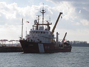 Limnos |
| Title | Survey Equipment | Description |
|---|---|---|
| Cruise report | (document not focused on specific equipment) | Chief Technician's report including personnel, purpose, equipment, and brief cruise narrative. |
| Survey Equipment | Survey Info | Data Type(s) | Data Collected |
|---|---|---|---|
| Gravity meter (wh) | --- | Gravity | |
| Echosounder | --- | Single Beam | 1989-010-FA-SE-001 (microfilm of CANADIAN DATA) |
| TI-4100 GPS | --- | Navigation | |
| GPS (wh) | --- | Navigation | |
| LaCoste-Romberg gravimeter G-179 | --- | Gravity | |
| Loran-C | --- | Navigation |
