Other ID: Cruise 19, Leg 1
Status: Completed
Organization(s): USGS, Woods Hole Coastal and Marine Science Center
Funding Program(s):
Principal Investigator(s): Kim D. Klitgord
Affiliate Investigator(s): Dr. Vyacheslav S. Yastrebov, Dr. Igor M. Sborshshikov
Information Specialist(s):
Data Type(s): Sonar: Sidescan, Imagery: Video, Imagery: Photo, Location-Elevation: Navigation
Scientific Purpose/Goals: MIR submersible diving program in east end of King's Trough: rock sampling and photographic study of the scarps that form the north and south walls of Freen Deep and the north wall of Peake Deep. Basement morphology and petrology study.
Vehicle(s):
Start Port/Location: Kiel, West Germany
End Port/Location: Washington, D.C.
Start Date: 1989-06-12
End Date: 1989-07-05
Equipment Used: Klein 531 sidescan, Video camera - deep sea, Camera- deep sea, Magnavox satellite positioning system
Information to be Derived: Samples and chemical analysis; Grain size analysis; Morphology;
Summary of Activity and Data Gathered: Dives: MIR-1 = 4 (#19-2096, 19-2103, 19-2106, and 19-2108), MIR-2 = 3 (#19-2098, 19-2103, and 19-2110); Dive 19-2103 = National Geographic photos; Dive rock samples: 50; Sediment core stations: 2 in Freen Deep; Sidescan sonar station: Palmer Ridge; Hydro station: Freen Deep.
Staff: Kim D. Klitgord
Affiliate Staff:
Dr. Vyacheslav S. Yastrebov - Chief Scientist
P.P. Shirshov Institute of Oceanology
Moscow
USSR; Dr. Nikolai L. Dobretsov - MIR science dive team
Institute of Geology and Geophysics
Novosibirsk
Siberia
USSR; Dr. Mikhail I. Kuzmin - MIR science dive team
Institute of Geochemistry
Irkutsk
Siberia
USSR; Dr. Nikita A. Bogdanov - Secretary General of IGC
Institute of the Lithosphere
Moscow
USSR; Dr. John F. Casey - petrologist
MIR science dive team
University of Houston
Houston
TX
USA; Dr. Igor M. Sborshshikov - co-Chief Scientist
MIR science dive team
P.P. Shirshov Institute of Oceanology
Moscow
USSR; Dr. Anatoly Sagalevitch - chief MIR pilot and head of operations
P.P. Shirshov Institute of Oceanology
Moscow
USSR; Dr. Alexander P. Lisitzin - science team
P.P. Shirshov Institute of Oceanology
Moscow
USSR; Dr. Lev P. Zonenshain - science team
P.P. Shirshov Institute of Oceanology
Moscow
USSR; Dr. Lev Natapov - science team
Ministry of Geology
Moscow
USSR; Dr. Susan M. Agar - science team
University of Leeds
Leeds
UK; Dr. Sergei Silantiev - metamorphic petrologist
Vernadsky Institute of Geochemistry
Moscow
USSR
Notes: This was one heck of a cruise...
Project = Mid- Atlantic Ridge Crest Processes, Mid- Atlantic Ridge Crest Processes
Location:
Kings Trough, Palmer Ridge, Freen Deep, Peake Deep, Mid-Atlantic Ridge, North Atlantic;
| Boundaries | |||
|---|---|---|---|
| North: 44.1 | South: 42.5 | West: -23.5 | East: -19 |
Platform(s):
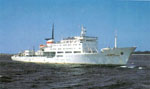 Akademik Mstislav Keldysh | 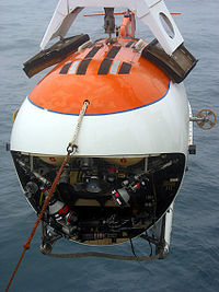 MIR-1 | MIR-2 |
| Title | Survey Equipment | Description |
|---|---|---|
| Cruise report | (document not focused on specific equipment) | Chief Scientist's cruise report including personnel, cruise objectives, equipment, tabulated information, trackmaps, cross-sections. |
| Survey Equipment | Survey Info | Data Type(s) | Data Collected |
|---|---|---|---|
| Klein 531 sidescan | --- | Sidescan | |
| Video camera - deep sea | --- | Video | |
| Camera- deep sea | --- | Photo | |
| Magnavox satellite positioning system | --- | Navigation |
