Other ID: F9-89-NC
Status: Completed
Organization(s): USGS, Woods Hole Coastal and Marine Science Center
Funding Program(s):
Principal Investigator(s): William Schwab
Affiliate Investigator(s): John Chin, Herman Karl - PMG
Information Specialist(s):
Data Type(s): Seismics: Sub Bottom Profiler, Sonar: Single Beam, Sonar: Sidescan, Electro-Magnetic: Gravity, Location-Elevation: Navigation
Scientific Purpose/Goals: Map continental shelf using AMS 120 sidescan sonar and Klein 100 kHz sidescan sonar.
Vehicle(s):
Start Port/Location: Redwood City, CA
End Port/Location: Drake's Bay, CA
Start Date: 1989-08-02
End Date: 1989-08-18
Equipment Used: 3.5 kHz, 10 kHz Bathymetry, AMS 120 sidescan, Klein 531 sidescan, Gravity meter (wh), Northstar 7000 LORAN-C, Trimble 4000AX GPS receiver, Del Norte, transponder net
Information to be Derived:
Summary of Activity and Data Gathered:
Staff: William Danforth, Thomas O'Brien, William Schwab, Jana DaSilva
Affiliate Staff:
Robin Bouse; Herman Karl - Co-Chief Sci.
PMG; John Chin - Co-Chief Sci.
PMG; Mike Hamer
Kaye Kinoshita
Larry Kooker
Mike Torresan
Hal Williams - PMG; Bob Elder - DSL-WHOI; Tom Dettweiler - Meridian Sciences
Notes: Original Center People field contained: Bill Schwab - Co-chief Sci.; Robin Bouse, Bill Danforth, Jana DaSilva, Tom O'Brien.
Location:
Farallon Islands, California, United States, North America, North Pacific;
| Boundaries | |||
|---|---|---|---|
| North: 38.02717982 | South: 37.48478742 | West: -123.40881938 | East: -122.15728473 |
Platform(s):
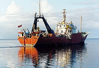
 Farnella |
Folger, D.W., Irwin, Barry J., McCullough, James R., Bouse, Robin M., Polloni, Christopher F., Dodd, James E., and O'Brien, T. F., 1990, Map showing free-air gravity anomalies around the Cape Verde Islands: U.S. Geological Survey Miscellaneous Field Studies Map MF-2098-A, scale 1:750,000, URL: https://pubs.er.usgs.gov/publication/mf2098A.
Sweeney, E.M., Danforth, W.W., Karl, H.A., O'Brien, T.F., and Schwab, W.C., 2004, The Gulf of the Farallones—Sidescan-sonar imagery: U.S. Geological Survey Open-File Report 2004-1082, https://doi.org/10.3133/ofr20041082.
| Title | Survey Equipment | Description |
|---|---|---|
| Sidescan log | AMS 120 sidescan | AMS120 watchstander's log with equipment configuration and adjustments, performance, start and end of lines, geologic observations. Covers cruises 1989-019-FA and 1989-020-FA. |
| Survey Equipment | Survey Info | Data Type(s) | Data Collected |
|---|---|---|---|
| 3.5 kHz | --- | Sub Bottom Profiler | |
| 10 kHz Bathymetry | --- | Single Beam | |
| AMS 120 sidescan | --- | Sidescan | Sidescan mosaic |
| Klein 531 sidescan | --- | Sidescan | |
| Gravity meter (wh) | --- | Gravity | |
| Northstar 7000 LORAN-C | --- | Navigation | 1989-020-FA-LN-001 (Navigation data) |
| Trimble 4000AX GPS receiver | --- | Navigation | |
| Del Norte, transponder net | --- | Navigation |