Other ID: none
Status: Completed
Organization(s): USGS, Woods Hole Coastal and Marine Science Center
Funding Program(s):
Principal Investigator(s): Frank T. Manheim, Peter Popenoe
Affiliate Investigator(s):
Information Specialist(s):
Data Type(s): Environmental Data: CTD, Environmental Data: Current, Environmental Data: Temperature, Imagery: Photo, Imagery: Video, Location-Elevation: Navigation, Sampling: Biology, Sampling: Geology, Seismics: Sub Bottom Profiler, Visual Identification: Submersible Observations
Scientific Purpose/Goals: To study the deep scour pits on the northern Blake Plateau to determine the nature of erosion or solution, the age and nature of the outcropping rocks, the nature of the biomass supporting large fish concentrations reported in this area, the thickness of the phosphorite-manganese pavements over the Blake Plateau, and the fracture patterns and their orientation; to visit the "Aluminaut Hole" and measure the water salinity within erosional pits to determine possible presence of fresh water nodules and their occurence; to determine if pavement is discontinuous; to examine and groundcheck features seen on GLORIA long-range sidescan sonar mosaic; to measure current velocity, temperature and direction throughout the area to determine the extent south-flowing undercurrents have contributed to scour topography; and to study the deepwater ahermatypic reef mounds.
Vehicle(s):
Start Port/Location: Norfolk, VA
End Port/Location: Norfolk, VA
Start Date: 1989-10-05
End Date: 1989-10-15
Equipment Used: Video camera - deep sea, Benthos model 372 camera and strobe, 70-mm camera, 3.5 kHz, Grab sampler, Temperature and salinity, Savonius rotor current meter, Dead reckoning, Submersible Observation
Information to be Derived:
Summary of Activity and Data Gathered: Sediment samplers were not placed into operating position due to heavy seas (must be emplaced by divers). Approximately 70 nautical miles (140 km) were traversed in view of the bottom. Approximately 35 nm of the bottom were recorded on video tape. Approximately 50 nm were recorded with sidescan sonar. Approximately 360 photographs of the bottom were made with hand-held cameras; 633 photos were taken with the external Benthos camera system.
Staff:
Affiliate Staff:
Notes: Project = EEZ Minerals, EEZ Minerals. Information brought over from Foghorn: view ports, incandescent lights, closed circuit television system, 10 underwater TV cameras, video tape recorder, 4 regular screens with two small enhanced screens fed to videotape machine along with date and time;Benthos 35mm external still camera with strobe light;70mm external (powerful) strobe for hand-held viewer cameras;forward looking sonar;3.5 kHz sub-bottom profiler;manipulator arm, sample basket sampling scoops;temperature-conductivity-salinity probe, Savonius rotor current meter;side-looking sonar.
Location:
Blake Plateau, United States, North America, North Atlantic;
| Boundaries | |||
|---|---|---|---|
| North: 31.8 | South: 30.9 | West: -79.2 | East: -79 |
Platform(s):
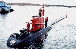 NR-1 | 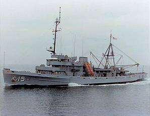 Sunbird |
Popenoe, P., and Manheim, F.T., 2001, Origin and history of the Charleston Bump--geological formations, currents, bottom conditions, and their relationship to Wreckfish habitats on the Blake Plateau, in Sedberry, G.R., ed., Island in the Stream--Oceanography and Fisheries of the Charleston Bump: American Fisheries Society Symposium, v. 25.
| Title | Survey Equipment | Description |
|---|---|---|
| Cruise report | (document not focused on specific equipment) | Chief Scientist's cruise report including personnel, purpose, equipment, tabulated information and extensive description of station information. Also includes trackmap, seismic profile location sketch, and several hand-drawn cross-sections. |
| Survey Equipment | Survey Info | Data Type(s) | Data Collected |
|---|---|---|---|
| Video camera - deep sea | --- | Video | |
| Benthos model 372 camera and strobe | --- | Photo | |
| 70-mm camera | --- | Photo | |
| 3.5 kHz | --- | Sub Bottom Profiler | |
| Grab sampler | --- | Biology Geology | |
| Temperature and salinity | --- | CTD Temperature | |
| Savonius rotor current meter | --- | Current | |
| Dead reckoning | --- | Navigation | |
| Submersible Observation | --- | Submersible Observations | 1989-029-FA-NL-001 (Chief Scientist's cruise report describing ship movement, personnel, equipment and data acquisition notes, daily narrative, dive logs, seafloor geology, trackmaps, etc.) |
