Other ID: 94-12
Status: Completed
Organization(s): USGS, Woods Hole Coastal and Marine Science Center
Funding Program(s):
Principal Investigator(s): David Twichell
Affiliate Investigator(s): Mohsen Badiey - U DE
Information Specialist(s):
Data Type(s): Sonar: Sidescan, Sonar: Single Beam, Location-Elevation: Navigation
Scientific Purpose/Goals: Sidescan survey LEO-15 area surveyed June 1991 to document storm changes to inner shelf setting.
Vehicle(s):
Start Port/Location: Lewes, DE
End Port/Location: Lewes, DE
Start Date: 1994-05-24
End Date: 1994-05-30
Equipment Used: Klein 531 sidescan, Q-MIPS sidescan sonar system, ODOM 200 kHz depth recorder, DGPS, Megapulse Accufix 500 LORAN-C
Information to be Derived:
Summary of Activity and Data Gathered: This was a 2-ship multidisciplinary acoustical survey: CTDs during daylight, sidescan sonar at night. Early sidescan problems were solved with second QMIPS trigger box. Entire area was successfully surveyed at 150-m spacing.
Staff: David Twichell, Kenneth F. Parolski
Affiliate Staff:
Mohsen Badiey - Ch. Sci.
4 grad students - U DE; Steve Forsythe
tech. - NRL-Orlando
FL
Notes: Original Center People field contained: Dave Twichell - co-chief sci., Ken Parolski - marine tech.
Location:
Little Egg Inlet, New Jersey, United States, North America, North Atlantic;
| Boundaries | |||
|---|---|---|---|
| North: 39.55 | South: 39.4 | West: -74.3 | East: -74.2 |
Platform(s):
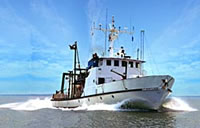
 Cape Henlopen |
Paskevich, V., Twichell, D.C., Badiey, M., Parolski, K., and Danforth, W., 1996, Sidescan sonar and navigation field data collected during Cape Henlopen 94-12 cruise (24-30 May, 1994): U.S. Geological Survey Open-File Report 96-83, https://doi.org/10.3133/ofr9683.
| Title | Survey Equipment | Description |
|---|---|---|
| Cruise report | (document not focused on specific equipment) | Chief Scientist's report including personnel, purpose, equpment, tabulated informatin, cruise summary, trackmap. |
| Q-Mips log | Klein 531 sidescan | Q-MIPS log containing line number, file names, start and end times and data acquisition notes. |
| Cruise log | (document not focused on specific equipment) | Cruise log with daily narrative of data acquisition and equipment configuration information. |
| Survey Equipment | Survey Info | Data Type(s) | Data Collected |
|---|---|---|---|
| Klein 531 sidescan | --- | Sidescan | 1994-031-FA-SO-001 (Sidescan Sonar Data ) |
| Q-MIPS sidescan sonar system | Computer used to log data. Specifically the cruise report indicates it was the system usually used with the SIS7000. | Sidescan | |
| ODOM 200 kHz depth recorder | --- | Single Beam | |
| DGPS | --- | Navigation | 1994-031-FA-LN-002 (Loran C navigation printout with 5 minute fixes, latitude, longitude, time delays, bearing, speed, etc.
) 1994-031-FA-LN-001-01 (Processed navigation) |
| Megapulse Accufix 500 LORAN-C | --- | Navigation |