Other ID: 9401
Status: Completed
Organization(s): USGS, Woods Hole Coastal and Marine Science Center
Funding Program(s):
Principal Investigator(s): Page Valentine
Affiliate Investigator(s):
Information Specialist(s):
Data Type(s): Sampling: Biology, Sampling: Geology, Location-Elevation: Navigation, Sonar: Sidescan, Imagery: Photo, Imagery: Video
Scientific Purpose/Goals: Document character/distribution of fisheries habitats on the northern edge (U.S./Canada) of Georges Bank; quantify trawling/dredging on epibenthic megafauna in fished/unfished areas; sidescan future GLOBEC site; and re-sidescan storm/fisheries impacted Stellwagen Bank.
Vehicle(s):
Start Port/Location: Woods Hole, MA
End Port/Location: Woods Hole, MA
Start Date: 1994-04-06
End Date: 1994-04-15
Equipment Used: Dredge, DGPS, Klein 531 sidescan, Osprey camera system
Information to be Derived:
Summary of Activity and Data Gathered:
Staff: Dann Blackwood, David Nichols, Nancy K. Soderberg, Eric A. Schmuck, Barbara A. Seekins, Page Valentine
Affiliate Staff:
Galo Escanero - URI
Notes: Sidescan records archived at USGS-Woods Hole. Video tapes/photos archived at USGS; URI-Narragansett, RI; NURP-UCONN-Groton,CT. Biological samples archived at URI.
Location:
Georges Bank, Stellwagen Bank, United States, North America, North Atlantic;
| Boundaries | |||
|---|---|---|---|
| North: 42.85798 | South: 41.19131 | West: -69.8427 | East: -68.17598 |
Platform(s):
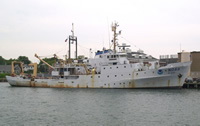 Albatross IV |
| Survey Equipment | Survey Info | Data Type(s) | Data Collected |
|---|---|---|---|
| Dredge | --- | Biology Geology | |
| DGPS | --- | Navigation | |
| Klein 531 sidescan | --- | Sidescan | |
| Osprey camera system | --- | Photo Video |
