Other ID: CSTL 95009
Status: Completed
Organization(s): USGS, Woods Hole Coastal and Marine Science Center
Funding Program(s):
Principal Investigator(s): William Schwab
Affiliate Investigator(s): Paul Gayes - CCU
Information Specialist(s):
Data Type(s): Location-Elevation: Navigation, Sonar: Sidescan, Sonar: Single Beam
Scientific Purpose/Goals: Image shoreface and inner shelf off Folly Beach, South Carolina.
Vehicle(s):
Start Port/Location: Isle of Palms, SC
End Port/Location: Isle of Palms, SC
Start Date: 1995-08-01
End Date: 1995-08-14
Equipment Used: ODOM 200 kHz depth recorder, DGPS, Klein 531 sidescan, 12 kHz
Information to be Derived:
Summary of Activity and Data Gathered:
Staff: William Danforth, Barry Irwin, David Nichols, William Schwab
Affiliate Staff:
Paul Gayes - CCU
Notes: Project = South Carolina Coastal Erosion, South Carolina Coastal Erosion
Information updated by VAC based on information in OFR97-473.
Location:
Folly Beach, South Carolina, United States, North America, North Atlantic;
| Boundaries | |||
|---|---|---|---|
| North: 32.69935 | South: 32.61509 | West: -79.9882 | East: -79.80331 |
Platform(s):
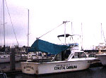
 MS Coastal |
Barnhardt, W.A. (ed.), 2009, Coastal change along the shore of northeastern South Carolina—the South Carolina coastal erosion study: U.S. Geological Survey Circular 1339, 77 p., https://doi.org/10.3133/cir1339.
Danforth, W.W., Bemis, B., Schwab, W.C., and Paskevich, V.F., 1997, Archive of the ISIS sidescan sonar and DGPS navigation field data collected on USGS Cruise 95009, 1-14 August, 1995: U.S. Geological Survey Open-File Report 97-473, https://doi.org/10.3133/ofr97473.
Barnhardt, W.A. (ed.), 2009, Coastal change along the shore of northeastern South Carolina—the South Carolina coastal erosion study: U.S. Geological Survey Open-File Report 2008-1206, URL: https://doi.org/10.3133/ofr20081206.
| Title | Survey Equipment | Description |
|---|---|---|
| Cruise report | (document not focused on specific equipment) | Chief Scientist's report including personnel, purpose, equipment, tabulated information, seismic line list, trackmap. |
| Survey Equipment | Survey Info | Data Type(s) | Data Collected |
|---|---|---|---|
| ODOM 200 kHz depth recorder | --- | Single Beam | |
| DGPS | --- | Navigation | 1995-009-FA-LN-001 (Navigation trackline plot for field activity 95009) 1995-009-FA-LN-002-01 (Navigation data) |
| Klein 531 sidescan | --- | Sidescan | 1995-009-FA-SO-001 (Digital tape(s) of SSS-KLEIN ) 1995-009-FA-SO-001-01 (Sidescan sonar data) |
| 12 kHz | --- | Single Beam |