Other ID: CH 17-95 Leg 1
Status: Completed
Organization(s): USGS, Woods Hole Coastal and Marine Science Center
Funding Program(s):
Principal Investigator(s): William Dillon
Affiliate Investigator(s): Joe Gettrust - NRL-Stennis Space Center
Information Specialist(s):
Data Type(s): Imagery: Photo, Imagery: Video, Location-Elevation: Navigation, Sampling: Geology, Seismics: Air Gun / Water Gun, Sonar: Sidescan
Scientific Purpose/Goals: Sidescan sonar and seismic imaging of Blake Ridge collapse structure.
Vehicle(s):
Start Port/Location: Beaufort, NC
End Port/Location: Beaufort, NC
Start Date: 1995-10-11
End Date: 1995-10-19
Equipment Used: Air gun, SIS-7000 sidescan, DGPS, Single channel hydrophone
Information to be Derived:
Summary of Activity and Data Gathered:
Staff: William Danforth, Rebecca Drury, Barry Irwin, Thomas O'Brien
Affiliate Staff:
Joe Gettrust - NRL; Mary Rowe - NRL; Larry Kooker - tech. - USGS-Menlo; Fred Hegg - tech. - Datasonics
Notes: Original Center People field contained: Bill Danforth - Ch. Sci.; Tom O'Brien - tech., Rebecca Drury - data curator, Barry Irwin - nav. tech., Greg Miller - tech.
Project = Gas Hydrate, Gas Hydrate
Information from Foghorn: 2-channel digital seismic system, 160 cu. in. airgun, Datasonics SIS-7000 mid-range sidescan sonar (Bob) system
Location:
Blake Ridge, Blake Spur, South Carolina, United States, North America, North Atlantic;
| Boundaries | |||
|---|---|---|---|
| North: 32.26597464 | South: 31.42657982 | West: -76.07790455 | East: -75.09147282 |
Platform(s):
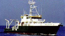
 Cape Hatteras |
Anton, C., Dillon, W.P., and Lee, M., 1999, Anomalous, nearly horizontal, seismic reflection at the Blake Ridge--Evidence for a gas trap crosses the base of gas hydrate stability [abs.]: , Eos, Transactions, American Geophysical Union, Spring Meeting.
Nealon, J.W., Dillon, W.P., Danforth, W.W., and O'Brien, T.F., 2002, Deep towed CHIRP profiles of the Blake Ridge collapse structure collected on USGS Cruises 92023 and 95023 aboard the R/V Cape Hatteras in 1992 and 1995: U.S. Geological Survey Open-File Report 2001-123, https://doi.org/10.3133/ofr01123.
Taylor, M.H., Dillon, W.P., Anton, C.H., and Danforth, W.W., 1999, Seismic-reflection surveys of the Blake Ridge, R/V Cape Hatteras, 1992 and 1995—Data acquisition, navigation and processing: U.S. Geological Survey Open-File Report 99-372, URL: https://doi.org/10.3133/ofr99372.
FAN 1995-023-FA has data viewable in the GeoMappApp/Virtual Ocean applications. To view this data in these applications go to http://www.geomapapp.org/ and http://www.virtualocean.org/. See the instructions for locating USGS data in these applications. You can also view the imagery created from the SEGY data at https://cmgds.marine.usgs.gov/images.php?cruise=1995-023-FA.
| Title | Survey Equipment | Description |
|---|---|---|
| Seismic log | Air gun | Seismic log containing equipment configuration, line numbers, times, equipment performance, and data quality. |
| Q-Mips log | SIS-7000 sidescan | Q-Mips log including line and file names, equipment performance, and bottom features. |
| Survey Equipment | Survey Info | Data Type(s) | Data Collected |
|---|---|---|---|
| Air gun | --- | Air Gun / Water Gun | |
| SIS-7000 sidescan | --- | Sidescan | 1995-023-FA-SO-002 (CD ROM disk of L7,8,9,10,11 BLAKE RIDGE, ) 1995-023-FA-NL-002 (CD ROM disk of L7,8,9,10,11 BLAKE RIDGE, ) Chirp seismic data 1995-023-FA-SO-001 (Digital tape(s) of SSS-SBTM L7-9, SSS-SBTM L10-11, SSS-SBTM L8, ) |
| DGPS | --- | Navigation | Nav data 1995-023-FA-LN-001-01 (Raw navigation) 1995-023-FA-LN-001-02 (Processed navigation) |
| Single channel hydrophone | --- | Air Gun / Water Gun Boomer Bubble Gun Sparker Sub Bottom Profiler | 1995-023-FA-SE-001 (Digital tape(s) of SSS-SBTM L7-9, SSS-SBTM L10-11, SSS-SBTM L8, ) 1995-023-FA-SE-001-01 (SEGY seismic data) |