Other ID: CH 17-95 Leg 2
Status: Completed
Organization(s): USGS, Woods Hole Coastal and Marine Science Center
Funding Program(s):
Principal Investigator(s): Edwin Roworth
Affiliate Investigator(s): Joe Gettrust - NRL-Stennis Space Center
Information Specialist(s):
Data Type(s): Seismics: Multichannel, Location-Elevation: Navigation
Scientific Purpose/Goals: Deep-towed multichannel profiling of Blake Ridge collapse structure, tie to ODP drillsites, structure near drillsites.
Vehicle(s):
Start Port/Location: Beaufort, NC
End Port/Location: Beaufort, NC
Start Date: 1995-10-27
End Date: 1995-11-06
Equipment Used: Multichannel seismics, DGPS
Information to be Derived:
Summary of Activity and Data Gathered:
Staff: Edwin Roworth
Affiliate Staff:
Joe Gettrust - Ch. Sci. - NRL; Mary Rowe - NRL; others
Notes: CH 17-95 Leg 1: Oct. 11-19, 1995, FA 95023; CH 17-95 Leg 2: Oct. 27 - Nov. 6, 1995, NRL cruise, no report. Original Center People field contained: Ed Roworth - tech.
Project = Gas Hydrates, Gas Hydrates
Location:
Blake Ridge, South Carolina, United States, North America, North Atlantic;
| Boundaries | |||
|---|---|---|---|
| North: 33.02709 | South: 29.15216 | West: -78.3325 | East: -73.87207 |
Platform(s):
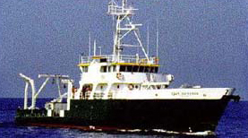
 Cape Hatteras |
Anton, C., Dillon, W.P., and Lee, M., 1999, Anomalous, nearly horizontal, seismic reflection at the Blake Ridge--Evidence for a gas trap crosses the base of gas hydrate stability [abs.]: , Eos, Transactions, American Geophysical Union, Spring Meeting.
| Survey Equipment | Survey Info | Data Type(s) | Data Collected |
|---|---|---|---|
| Multichannel seismics | --- | Multichannel | |
| DGPS | --- | Navigation |