Other ID: DIAN9625
Status: Completed
Organization(s): USGS, Woods Hole Coastal and Marine Science Center
Funding Program(s):
Principal Investigator(s): Page Valentine
Affiliate Investigator(s): Peter Auster, NOAA at UCONN, Avery Pt., Groton, CT
Information Specialist(s):
Data Type(s): Imagery: Photo, Imagery: Video, Location-Elevation: Navigation, Sampling: Biology, Sampling: Geology
Scientific Purpose/Goals: Acquire sediment samples, video images, and still photos of the sea bed that will be used to interpret sidescan sonar imagery and compile maps of Stellwagen Bank NMS.
Vehicle(s):
Start Port/Location: Gloucester, MA
End Port/Location: Gloucester, MA
Start Date: 1996-05-16
End Date: 1996-05-23
Equipment Used: ROV, DGPS, Video camera - deep sea, Grab sampler, Camera- deep sea
Information to be Derived:
Summary of Activity and Data Gathered:
Staff: Dann Blackwood, Page Valentine, David Piccirilli, Brenton B. Taylor
Affiliate Staff:
Peter Auster and crew
Notes:
Project = Stellwagen Bank NMS Mapping Project, Stellwagen Bank NMS Mapping Project
Location:
Stellwagen Bank region, North America, North Atlantic;
| Boundaries | |||
|---|---|---|---|
| North: 42.54105184 | South: 42.08089743 | West: -70.42677202 | East: -70.02546886 |
Platform(s):
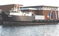 Diane G |
Valentine, P.C., and Cross, V.A., 2023, Geospatial datasets of seabed topography, sediment mobility, and the distribution of geologic substrates in quadrangle 5 of the Stellwagen Bank National Marine Sanctuary region offshore of Boston, Massachusetts: U.S. Geological Survey data release, https://doi.org/10.5066/P9W9BN3S.
Valentine, P.C., and Gallea, L.B., 2015, Seabed maps showing topography, ruggedness, backscatter intensity, sediment mobility, and the distribution of geologic substrates in quadrangle 6 of the Stellwagen Bank National Marine Sanctuary region offshore of Boston, Massachusetts: U.S. Geological Survey Scientific Investigations Map 3341, 10 sheets, scale 1:25,000, and 21-p. pamphlet, https://doi.org/10.3133/sim3341.
Valentine, P.C., Gallea, L.B., Blackwood, D.S., and Twomey, E.R., 2010, Seabed photographs, sediment texture analyses, and sun-illuminated sea floor topography in the Stellwagen Bank National Marine Sanctuary region off Boston, Massachusetts: U.S. Geological Survey Data Series 469, available at https://doi.org/10.3133/ds469.
Valentine, P.C., Baker, J.L., Unger, T.S., Scully, L.A., and Fuller, S.J., 2005, Sea floor image maps showing topography, sun-illuminated topography, backscatter intensity, ruggedness, slope, and the distribution of boulder ridges and bedrock outcrops in the Stellwagen Bank National Marine Sanctuary region off Boston, Massachusetts: U.S. Geological Survey Scientific Investigations Map 2840, https://doi.org/10.3133/sim2840.
| Survey Equipment | Survey Info | Data Type(s) | Data Collected |
|---|---|---|---|
| ROV | --- | Photo Video Biology Geology | |
| DGPS | --- | Navigation | |
| Video camera - deep sea | --- | Video | |
| Grab sampler | --- | Biology Geology | 1996-025-FA-SC-001 (GRAB samples) |
| Camera- deep sea | --- | Photo | 1996-025-FA-NL-001 (CD ROM disk of BOTTOMPHOTO STELL JD137, BOTTOMPHOTO STELL JD140, BOTTOMPHOTO STELL JD143, ) 1996-025-FA-PH-001 (CD ROM disk of BOTTOMPHOTO STELL JD137, BOTTOMPHOTO STELL JD140, BOTTOMPHOTO STELL JD143, ) |
