Other ID: none
Status: Completed
Organization(s): USGS, Woods Hole Coastal and Marine Science Center
Funding Program(s):
Principal Investigator(s): Kathryn Scanlon Catanach
Affiliate Investigator(s): Churchill Grimes - NOAA
Information Specialist(s): Kathryn Scanlon Catanach
Data Type(s): Seismics: Boomer, Location-Elevation: Navigation, Sonar: Sidescan, Seismics: Sub Bottom Profiler, Sonar: Single Beam
Scientific Purpose/Goals: Sidescan survey of grouper spawning habitat.
Vehicle(s):
Start Port/Location: Pascagoula, MS
End Port/Location: Panama City, FL
Start Date: 1997-03-20
End Date: 1997-03-31
Equipment Used: GeoPulse uniboom, Single channel hydrophone, DGPS, Edgetech DF-1000 sidescan sonar, ISIS, 3.5 kHz, Echosounder
Information to be Derived:
Summary of Activity and Data Gathered: 100 line-km of boomer data; 1185 line-km of sidescan sonar and 3.5 data.
Staff: Jane Denny, Kathryn Scanlon Catanach, Kenneth F. Parolski, Scott Harrison
Affiliate Staff:
Cliff Harper - NOAA (E.T.)
Notes: Original Center People field contained: Kathy Scanlon (Ch.Sci.); Ken Parolski (E.T.); Jane Denny (sidescan sonar processing); Scott Harrison (sidescan sonar processing).
Project = West Florida Shelf Edge Habitat Mapping, West Florida Shelf Edge Habitat Mapping
Location:
west Florida shelf edge, Florida, Gulf of Mexico, United States, North America, North Atlantic;
| Boundaries | |||
|---|---|---|---|
| North: 29.63267 | South: 24.89983 | West: -86.2407 | East: -83.65783 |
Platform(s):
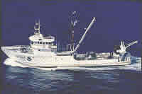
 Chapman |
Briere, P.R., Scanlon, K.M., Gledhill, C.T., Koenig, C.C., and Fitzhugh, G., 1999, West Florida Shelf—Sidescan-sonar and sediment data from shelf-edge habitats in the northeastern Gulf of Mexico: U.S. Geological Survey Open-File Report 99-589, CD-ROM, URL: https://doi.org/10.3133/ofr99589.
Scanlon, K.M., Coleman, Felicia C., and Koenig, Christopher C., 2005, Pockmarks on the outer shelf in the northern Gulf of Mexico; gas-release features or habitat modifications by fish?, in Barnes, P.W., and Thomas, J.P., eds., Benthic habitats and the effects of fishing: American Fisheries Society Symposium 41, v. 41.
| Title | Survey Equipment | Description |
|---|---|---|
| Navigation log | DGPS | GPS navigation log containing line number, time, latitude, and longitude. Also includes cruise personnel. |
| Navigation log | DGPS | Continuation navigation log containing line number, time, latitude, and longitude. Also has slant range and antenna configuration. |
| Sidescan log | Edgetech DF-1000 sidescan sonar | Seismic/ISIS field log with line and file names and start and end times. |
| Survey Equipment | Survey Info | Data Type(s) | Data Collected |
|---|---|---|---|
| GeoPulse uniboom | --- | Boomer | |
| Single channel hydrophone | --- | Air Gun / Water Gun Boomer Bubble Gun Sparker Sub Bottom Profiler | |
| DGPS | --- | Navigation | |
| Edgetech DF-1000 sidescan sonar | --- | Sidescan | Sidescan mosaic |
| ISIS | --- | Sidescan | |
| 3.5 kHz | --- | Sub Bottom Profiler | 1997-005-FA-SE-001 ( Collection of paper record displays of seismic data( 3.5K) for lines ) |
| Echosounder | --- | Single Beam | Bathymetry GIS data |