Other ID: OC387
Status: Completed
Organization(s): USGS, Woods Hole Coastal and Marine Science Center
Funding Program(s):
Principal Investigator(s): Page Valentine
Affiliate Investigator(s): WHOI: Hanu Singh, Cabell Davis, Scott Gallegher; SBNMS: James Lindholm
Information Specialist(s): Page Valentine
Data Type(s): Imagery: Photo, Imagery: Video
Scientific Purpose/Goals: Seabed photographic imagery and sidescan from AUVs for habitat mapping and classification.
Vehicle(s):
Start Port/Location: Woods Hole, MA
End Port/Location: Woods Hole, MA
Start Date: 2003-03-23
End Date: 2003-03-26
Equipment Used: ROV
Information to be Derived: Habitat maps;
Summary of Activity and Data Gathered: Conducted 10 transects with the Seabed AUV over various seabed (habitat) types, including gravel, boulder reefs, mobile and immobile sand, and mud. AUV digital camera collected up to 2500 photos per transect. Original data (photos, depth, temp data) archived at the Deep Submergence Lab at WHOI.
Staff: Page Valentine, P. Soupy Alexander
Affiliate Staff:
Scientists and engineers from WHOI and SBNMS
Notes: This is an engineering cruise to test the capabilities of 2 AUVs and a benthic camera sled for benthic habitat mapping. Test sites will be located in the Stellwagen Bank NMS region.
Project = Stellwagen Bank NMS Habitat Mapping, Stellwagen Bank NMS Habitat Mapping
Location:
Stellwagen Bank, Massachusetts, United States, North America, Gulf of Maine, North Atlantic,
| Boundaries | |||
|---|---|---|---|
| North: 42.8 | South: 42.08333 | West: -70.6 | East: -70.0333 |
Platform(s):
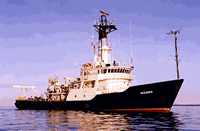
 Oceanus |
| Survey Equipment | Survey Info | Data Type(s) | Data Collected |
|---|---|---|---|
| ROV | --- | Photo Video Biology Geology |