Other ID: none
Status: Completed
Organization(s): USGS, Woods Hole Coastal and Marine Science Center
Funding Program(s):
Principal Investigator(s): Thomas O'Brien
Affiliate Investigator(s): Jeff Donnelly, WHOI
Information Specialist(s): Thomas O'Brien
Data Type(s): Seismics: Boomer, Location-Elevation: Navigation
Scientific Purpose/Goals: Geophysical survey of Oyster Pond.
Vehicle(s):
Start Port/Location: Porto Oyster Pondo
End Port/Location: Porto Oyster Pondo
Start Date: 2007-03-24
End Date: 2007-03-24
Equipment Used: Boomer, Real Time Kinematic GPS
Information to be Derived:
Summary of Activity and Data Gathered: 10 Kilometers of sidescan and sub-bottom data were collected.
Staff: Emile Bergeron, William Danforth, Barry Irwin, Thomas O'Brien, Charles Worley
Affiliate Staff:
Jeff Donnelly
Woods Hole Oceanographic Institution
Notes:
Location:
Oyster Pond, Falmouth, Massachusetts, United States, North America;
| Boundaries | |||
|---|---|---|---|
| North: 41.55417 | South: 41.54028 | West: -70.6403 | East: -70.63472 |
Platform(s):
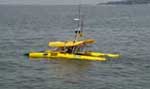 Iris |
| Survey Equipment | Survey Info | Data Type(s) | Data Collected |
|---|---|---|---|
| Boomer | --- | Boomer | |
| Real Time Kinematic GPS | --- | Navigation |
