Other ID: none
Status: Completed
Organization(s): USGS, Woods Hole Coastal and Marine Science Center
Funding Program(s):
Principal Investigator(s): Lawrence Poppe
Affiliate Investigator(s):
Information Specialist(s): Lawrence Poppe, Nancy K. Soderberg
Data Type(s): Location-Elevation: Navigation, Sampling: Biology, Sampling: Geology, Seismics: Sub Bottom Profiler, Visual Identification: Species ID, Biological Field Study: Experiments (biological), Biological Field Study: Surveys (biological), Imagery: Photo, Imagery: Video
Scientific Purpose/Goals: Ground truth NOAA survey of Woods Hole (H11077) with sub-bottom profiles and bottom sampling and photography.
Vehicle(s):
Start Port/Location: Woods Hole, MA
End Port/Location: Woods Hole, MA
Start Date: 2007-11-14
End Date: 2007-11-19
Equipment Used: SeaBOSS, Digital camera, DGPS, Edgetech chirp subbottom profiler 512i
Information to be Derived: Grain size analysis; Sea floor map; Bathymetric maps;
Summary of Activity and Data Gathered: A total of 58 stations were occupied (44 sampling and photography; 14 photography only). Chirp high-resolution seismic reflection data were collected along 12.6 km of tracklines.
Staff: Dann Blackwood, David Foster, Katherine McMullen, Charles Worley
Affiliate Staff:
Notes: Cruise plans involved 0.5 days of seismic profiling and 1.5 days of bottom sampling and photography. Original Center People field contained: Dave Foster (ship operator/seismic technician); Chuck Worley (ship operator/seismic technician); Dann Blackwood (photographer/SEABOSS operator); Kate McMullen (field technician/watch stander).
Project = Sea and Lake Floor Mapping, Sea and Lake Floor Mapping
Location:
Woods Hole, Massachusetts, United States, North America, North Atlantic;
| Boundaries | |||
|---|---|---|---|
| North: 41.52778 | South: 41.50556 | West: -70.6917 | East: -70.65556 |
Platform(s):
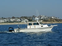
 Rafael |
Poppe, L.J., McMullen, K.Y., Foster, D.S., Blackwood, D.S., Williams, S.J., Ackerman, S.D., Barnum, S.R., and Brennan, R.T., 2008, Sea-floor character and sedimentary processes in the vicinity of Woods Hole, Massachusetts: U.S. Geological Survey Open-File Report, https://doi.org/10.3133/ofr20081004.
FAN 2007-034-FA has data viewable in the GeoMappApp/Virtual Ocean applications. To view this data in these applications go to http://www.geomapapp.org/ and http://www.virtualocean.org/. See the instructions for locating USGS data in these applications. You can also view the imagery created from the SEGY data at https://cmgds.marine.usgs.gov/images.php?cruise=2007-034-FA.
| Title | Survey Equipment | Description |
|---|---|---|
| Sample log | SeaBOSS | Sample log including station location, time, data acquired, and station description. |
| Survey Equipment | Survey Info | Data Type(s) | Data Collected |
|---|---|---|---|
| SeaBOSS | --- | Surveys (biological) Experiments (biological) Species ID Photo Video Geology Biology | 2007-034-FA-VD-001 (2 Hi-8 bottom video tapes: 120-minutes each.) 2007-034-FA-PH-001 (390 bottom photos from 58 sampling stations) 2007-034-FA-SC-001 (58 samples from 44 sampling stations: sample ID #s 07034 WH 1-4, 6, 7, 9-59, and 61.) 2007-034-FA-NL-001 (Video/Camera/Samples Log) 2007-034-FA-VD-001-01 (Bottom Video Transects: 4 DVDs from 2 original Hi8 video tapes.) |
| Digital camera | --- | Photo | 2007-034-FA-PH-002 (D. Blackwood's deck photos: 57 digital photos.) |
| DGPS | --- | Navigation | 2007-034-FA-NL-002 (Navigation log containing line numbers and SOL and EOL times.) |
| Edgetech chirp subbottom profiler 512i | --- | Sub Bottom Profiler | 2007-034-FA-SE-001 (12.6 km of chirp Edgetech 512i high-resolution seismic-reflection data (11 tracklines)) Chirp seismic data 2007-034-FA-SE-001-01 (Processed seismic data: JSF files were converted to SEG-Y files that were further processed and plotted as JPEG format chirp line shot images. The images were used in data release (Open-File Report). (Includes nav data.)) 2007-034-FA-SE-001-02 (Raw SEGY data converted from JSF data) |