


Illustration of the NIMBBLE (New instrument for making bottom boundary layer evaluations). The NIMBBLE is a low-profile platform with two acoustic Doppler velocimeters and an upward-looking acoustic Doppler profilers.
Coastal Model Applications and Field Measurements Active
By Woods Hole Coastal and Marine Science Center
August 28, 2018
Numerical models are used by scientists, engineers, coastal managers, and the public to understand and predict processes in the coastal ocean. This project supports the development and application of open-source coastal models and has several objectives: 1) improve the code of numerical sediment-transport models by implementing new or improved algorithms; 2) obtain measurements of coastal ocean processes to test and verify models; 3) develop new instruments or analysis techniques to make these measurements; and 4) develop software tools and standards to facilitate analysis, comparison, and visualization of observations and models. Study sites are selected for characteristics needed for model development and testing, as well as to address issues of national or regional importance.
This project houses several components, including: model code development; advances in instrumentation, field measurements, and analysis; development of standards and software tools for analysis of model output and comparison with observations; and model applications intended to test model capabilities, capitalize on unique partnering opportunities or field experiments, or address problems of societal relevance that are urgent and/or require new modeling capabilities.
Numerical ocean models are used by scientists, engineers, and coastal managers to understand and predict the effects of physical, biological, and chemical processes in the coastal ocean. This project has four objectives: 1) improve the code of open-source numerical models by implementing new or improved algorithms for processes related to sediment transport; 2) provide measurements of coastal ocean processes to test and verify models; and 3) develop new instruments or analysis techniques to make these measurements; and 4) develop software tools and standards to facilitate incorporation of observations with models and comparison among models. The overall objective is to support development of open-source models that are useful for addressing important problems related to natural hazards and ecosystem change in the coastal ocean.

Sources/Usage: Public Domain. View Media Details
Below are other science projects associated with this project.
Coastal Model Applications and Field Measurements- Ocean Model Contributions
The U.S. Geological Survey (USGS) and Woods Hole Oceanographic Institution (WHOI) led a project funded by the National Oceanographic Partnership Program (NOPP) with support from the Office of Naval Research (ONR) and the National Science Foundation (NSF), to develop a community sediment-transport modeling system (CSTMS).
Coastal Model Applications and Field Measurements- Field Measurements and Model Applications
Several components of this project are applications to evaluate the model against critical field measurements or to test new model components. Data from field measurements is described in our publications and available in our databases.
Coastal Model Applications and Field Measurements- Tools and Standards for Ocean Modeling
Ocean models provide critical information for coastal and marine spatial planning, emergency responders and for understanding implications of climate change and human activities. Models are run by numerous academic institutions and government agencies, typically with different access protocols that stifle use, comparison with data, and innovation.
Coastal Model Applications and Field Measurements- Advances in Instrumentation
Ongoing acquisition of new instruments and development of analytical methods provides us with the means to make better observations of coastal ocean processes. The measurements provide us with insight and data for critical evaluation of model performance. Advances in a range of measurement capabilities, including bottom stress, sediment erodibility, water properties and nutrient concentrations...
Below are multimedia items associated with this project.

Illustration of the NIMBBLE (New instrument for making bottom boun
Illustration of the NIMBBLE (New instrument for making bottom boundary layer evaluations). The NIMBBLE is a low-profile platform with two acoustic Doppler velocimeters and an upward-looking acoustic Doppler profilers.

Map of daily-averaged ocean surface current data
Map of daily-averaged ocean surface current data integrated from multiple IOOS Partner forecast models
Map of daily-averaged ocean surface current data integrated from multiple IOOS Partner forecast models

Relative seagrass biomass in West Falmouth Harbor, MA
Relative seagrass biomass in West Falmouth Harbor, MA, under current and potential future nitrogen loading scenarios. Seagrass biomass increases in western (seaward) portions of the harbor while eastern (landward) areas see new colonization by seagrass.
Relative seagrass biomass in West Falmouth Harbor, MA, under current and potential future nitrogen loading scenarios. Seagrass biomass increases in western (seaward) portions of the harbor while eastern (landward) areas see new colonization by seagrass.

Barnegat Bay residence times in days
Barnegat Bay residence times in days for (a) scenario T, only tidal forcing; (b) scenario TB, combined offshore hydrodynamic forcing; (c) scenario TBR, streamflow with combined hydrodynamic forcing; and (d) scenario TBRM, full suite with meteorological forcing
Barnegat Bay residence times in days for (a) scenario T, only tidal forcing; (b) scenario TB, combined offshore hydrodynamic forcing; (c) scenario TBR, streamflow with combined hydrodynamic forcing; and (d) scenario TBRM, full suite with meteorological forcing

Deployment of an instrumented quadrapod off Martha’s Vineyard
Deployment of an instrumented quadrapod off Martha’s Vineyard, November 2014.
Deployment of an instrumented quadrapod off Martha’s Vineyard, November 2014.
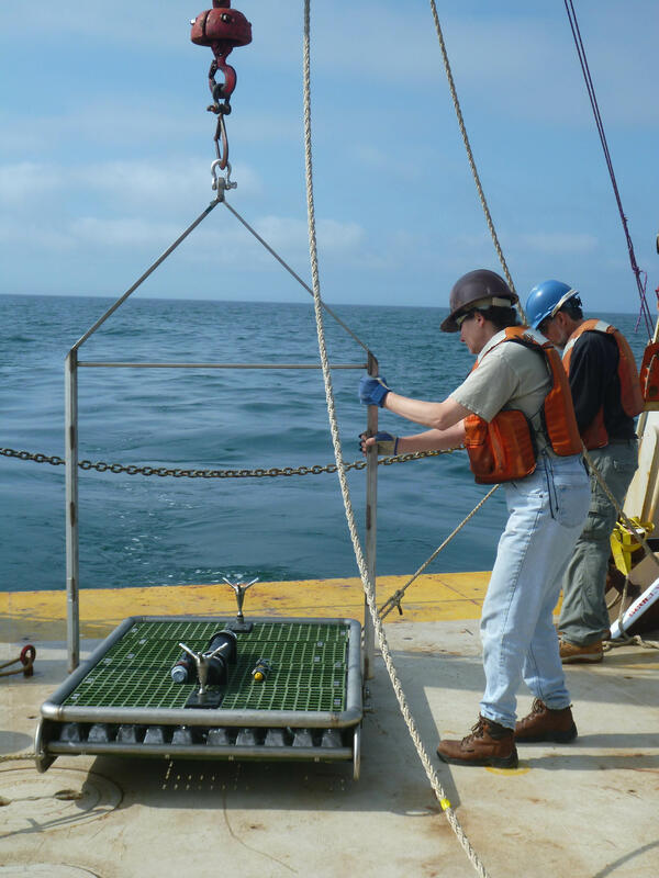
Marinna Martini prepares to deploy a NIMBBLE from the R/V Connecticut
Marinna Martini prepares to deploy a NIMBBLE from the R/V Connecticut south of Martha's Vineyard
Marinna Martini prepares to deploy a NIMBBLE from the R/V Connecticut south of Martha's Vineyard

USGS tilt current meter (white cylinder) in overwash channel
USGS tilt current meter (white cylinder) in overwash channel in the Sandwich Town Beach flooded during a Nor'Easter in March 2014
USGS tilt current meter (white cylinder) in overwash channel in the Sandwich Town Beach flooded during a Nor'Easter in March 2014

Bathymetry of the New England inner shelf and south shore of Martha’s
Bathymetry of the New England inner shelf and south shore of Martha’s Vineyard with model grids
Bathymetry of the New England inner shelf and south shore of Martha’s Vineyard with model grids

Comparison of observed near-bed velocities and modeled near-bed veloci
Comparison of observed near-bed velocities and modeled near-bed velocities using several bottom-roughness formulations. Velocity vectors are overlaid on map of backscatter from the sea floor showing regions with coarse sand (light color) and fine sand (dark colors). White lines are bathymetry contours.
Comparison of observed near-bed velocities and modeled near-bed velocities using several bottom-roughness formulations. Velocity vectors are overlaid on map of backscatter from the sea floor showing regions with coarse sand (light color) and fine sand (dark colors). White lines are bathymetry contours.
- Overview
Numerical models are used by scientists, engineers, coastal managers, and the public to understand and predict processes in the coastal ocean. This project supports the development and application of open-source coastal models and has several objectives: 1) improve the code of numerical sediment-transport models by implementing new or improved algorithms; 2) obtain measurements of coastal ocean processes to test and verify models; 3) develop new instruments or analysis techniques to make these measurements; and 4) develop software tools and standards to facilitate analysis, comparison, and visualization of observations and models. Study sites are selected for characteristics needed for model development and testing, as well as to address issues of national or regional importance.
This project houses several components, including: model code development; advances in instrumentation, field measurements, and analysis; development of standards and software tools for analysis of model output and comparison with observations; and model applications intended to test model capabilities, capitalize on unique partnering opportunities or field experiments, or address problems of societal relevance that are urgent and/or require new modeling capabilities.
Numerical ocean models are used by scientists, engineers, and coastal managers to understand and predict the effects of physical, biological, and chemical processes in the coastal ocean. This project has four objectives: 1) improve the code of open-source numerical models by implementing new or improved algorithms for processes related to sediment transport; 2) provide measurements of coastal ocean processes to test and verify models; and 3) develop new instruments or analysis techniques to make these measurements; and 4) develop software tools and standards to facilitate incorporation of observations with models and comparison among models. The overall objective is to support development of open-source models that are useful for addressing important problems related to natural hazards and ecosystem change in the coastal ocean.
Sources/Usage: Public Domain. View Media DetailsRotary side scan images at a grain-size boundary at a 12-m deep site south of Martha’s Vineyard. Gray images are fan-beam sonar backscatter amplitudes, and colored insets are bathymetry, with 0.02-m contours. Both images were made at the same location under different wave conditions, as indicated in the bottom panel, where ubr is wave-orbital velocity (m/s) and wave dir. (degrees True) is wave propagation direction (relative to north). - Science
Below are other science projects associated with this project.
Coastal Model Applications and Field Measurements- Ocean Model Contributions
The U.S. Geological Survey (USGS) and Woods Hole Oceanographic Institution (WHOI) led a project funded by the National Oceanographic Partnership Program (NOPP) with support from the Office of Naval Research (ONR) and the National Science Foundation (NSF), to develop a community sediment-transport modeling system (CSTMS).Coastal Model Applications and Field Measurements- Field Measurements and Model Applications
Several components of this project are applications to evaluate the model against critical field measurements or to test new model components. Data from field measurements is described in our publications and available in our databases.Coastal Model Applications and Field Measurements- Tools and Standards for Ocean Modeling
Ocean models provide critical information for coastal and marine spatial planning, emergency responders and for understanding implications of climate change and human activities. Models are run by numerous academic institutions and government agencies, typically with different access protocols that stifle use, comparison with data, and innovation.Coastal Model Applications and Field Measurements- Advances in Instrumentation
Ongoing acquisition of new instruments and development of analytical methods provides us with the means to make better observations of coastal ocean processes. The measurements provide us with insight and data for critical evaluation of model performance. Advances in a range of measurement capabilities, including bottom stress, sediment erodibility, water properties and nutrient concentrations... - Multimedia
Below are multimedia items associated with this project.
Illustration of the NIMBBLE (New instrument for making bottom bounIllustration of the NIMBBLE (New instrument for making bottom boundary layer evaluations). The NIMBBLE is a low-profile platform with two acoustic Doppler velocimeters and an upward-looking acoustic Doppler profilers.
Illustration of the NIMBBLE (New instrument for making bottom boundary layer evaluations). The NIMBBLE is a low-profile platform with two acoustic Doppler velocimeters and an upward-looking acoustic Doppler profilers.
Map of daily-averaged ocean surface current dataMap of daily-averaged ocean surface current data integrated from multiple IOOS Partner forecast models
Map of daily-averaged ocean surface current data integrated from multiple IOOS Partner forecast models
Relative seagrass biomass in West Falmouth Harbor, MARelative seagrass biomass in West Falmouth Harbor, MA, under current and potential future nitrogen loading scenarios. Seagrass biomass increases in western (seaward) portions of the harbor while eastern (landward) areas see new colonization by seagrass.
Relative seagrass biomass in West Falmouth Harbor, MA, under current and potential future nitrogen loading scenarios. Seagrass biomass increases in western (seaward) portions of the harbor while eastern (landward) areas see new colonization by seagrass.
Barnegat Bay residence times in daysBarnegat Bay residence times in days for (a) scenario T, only tidal forcing; (b) scenario TB, combined offshore hydrodynamic forcing; (c) scenario TBR, streamflow with combined hydrodynamic forcing; and (d) scenario TBRM, full suite with meteorological forcing
Barnegat Bay residence times in days for (a) scenario T, only tidal forcing; (b) scenario TB, combined offshore hydrodynamic forcing; (c) scenario TBR, streamflow with combined hydrodynamic forcing; and (d) scenario TBRM, full suite with meteorological forcing
Deployment of an instrumented quadrapod off Martha’s VineyardDeployment of an instrumented quadrapod off Martha’s Vineyard, November 2014.
Deployment of an instrumented quadrapod off Martha’s Vineyard, November 2014.
Marinna Martini prepares to deploy a NIMBBLE from the R/V ConnecticutMarinna Martini prepares to deploy a NIMBBLE from the R/V Connecticut south of Martha's Vineyard
Marinna Martini prepares to deploy a NIMBBLE from the R/V Connecticut south of Martha's Vineyard
USGS tilt current meter (white cylinder) in overwash channelUSGS tilt current meter (white cylinder) in overwash channel in the Sandwich Town Beach flooded during a Nor'Easter in March 2014
USGS tilt current meter (white cylinder) in overwash channel in the Sandwich Town Beach flooded during a Nor'Easter in March 2014
Bathymetry of the New England inner shelf and south shore of Martha’sBathymetry of the New England inner shelf and south shore of Martha’s Vineyard with model grids
Bathymetry of the New England inner shelf and south shore of Martha’s Vineyard with model grids
Comparison of observed near-bed velocities and modeled near-bed velociComparison of observed near-bed velocities and modeled near-bed velocities using several bottom-roughness formulations. Velocity vectors are overlaid on map of backscatter from the sea floor showing regions with coarse sand (light color) and fine sand (dark colors). White lines are bathymetry contours.
Comparison of observed near-bed velocities and modeled near-bed velocities using several bottom-roughness formulations. Velocity vectors are overlaid on map of backscatter from the sea floor showing regions with coarse sand (light color) and fine sand (dark colors). White lines are bathymetry contours.
- Publications
- Web Tools