
Test Case 1
Channel Flow

|
|
This case provides a fundamental check of the ability of a model to 1) represent a simple flow, 2) flux material from the bed, and 3) develop a suspended-sediment profile.
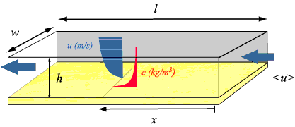
DomainThe model domain is a long, narrow rectangular box. Bottom SedimentSingle grain size on bottom ForcingInflow boundary condition only Boundary ConditionsInflow maintained as steady flow, depth-mean flow <u> = 1 m/s Output (ASCII files suitable for plotting)Velocity profile at x = 8000 m Physical ConstantsGravitational acceleration g = 9.81 m/s² NoteIf a model incorporates physical constants that differ from these, and/or automatically calculates some values specified here, please specify the values used. ResultsSolution to Test Case 1: Straight Flume
|
These pages are for communication among a group of researchers studying experimental methods of modeling and visualizing natural systems using digital (numerical) techniques. The methods and models discussed are in preliminary, developmental, stages and may be incorrect. The pages will be changed or removed without warning. The U.S. Geological Survey makes no representation as to the accuracy, correctness, or utility of any data, model, model results, or technique associated with these pages.
Skip Navigation

 U.S. Department of the Interior |
U.S. Geological Survey
U.S. Department of the Interior |
U.S. Geological Survey
URL: woodshole.er.usgs.gov/project-pages/sediment-transport/Test_Case_1.htm
Page Contact Information: WHSC Webmaster
This page last modified on Monday, 05-Dec-2016 16:31:20 EST