Woods Hole Coastal and Marine Science Center


Provisional Pages: Work in Progress

Test Case34

Lake Signell

Jump to project page. Go to test cases page. Skip navigational links

This case provides a fundamental check of the ability of a model to represent 1) wind driven transport in a closed basin, 2) wave-current influences on bottom friction and sediment resuspension, 3) flux of two grain sizes from the bed, and 4) resuspension, transport, and deposition of suspended-sediment. Lake Signell derives its name from the paper by Signell et al. (1990) Journal of Geophysical Research 95(C6): 9671-9673.
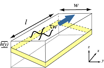
Figure showing the layout of test case 3, the hypothetical Lake Signell

Domain

The domain is an enclosed basin, rectangular in plan view, with a sloping bottom.
Length (east-west) l = 50,000 m
Width (north-south) w =10,000 m
Depth h = 18 m at the northern end, decreasing linearly to 2 m at the southern end

Bottom Sediment

Grain size:
Sand  
Size (D50) = 0.1 mm (fine sand)  
Density ρs = 2650 kg/m³  
Settling velocity = 0.1 mm/s  
Critical shear stress τc = 0.05 N/m²  
Thickness = 0.005 m  
Erosion rate = 5 e-5 kg/m² /s  


Forcing

No Coriolis
No heating/cooling

Wind:
Wind speed = 13 m/s (tau = 0.25 Pa), blowing along the lake to the east
Waves:
RMS wave height = 0.5 m
Period = 5 seconds
Direction: propagating in wind direction

Initial Conditions

u = 0 m³ /s
Salinity = 0
T = 20° C

Boundary Conditions

North, south, east, and west sides = walls with no fluxes, no friction
Bottom roughness zo = 0.015 m in absence of waves
Surface roughness zos = 0.02 m
Sediment flux calculated by model
Surface = free surface, no fluxes of heat or salt (momentum fluxes associated with wind)

Output at Steady State (ASCII files suitable for plotting)

Velocity field at profile at x = 40,000 m
Bed thickness

Physical Constants

Gravitational acceleration g = 9.81 m/s²
Von Karman's constant κ = 0.41
Dynamic viscosity (and minimum diffusivity) ν = 1e-6 m² /s

Note

If a model incorporates physical constants that differ from these, and/or automatically calculates some values specified here, please specify the values used.

Results

Solution to Test Case 3: Lake Signell

Jump to top of page Jump to project page.


Skip provisional clause.
These pages are for communication among a group of researchers studying experimental methods of modeling and visualizing natural systems using digital (numerical) techniques. The methods and models discussed are in preliminary, developmental, stages and may be incorrect. The pages will be changed or removed without warning. The U.S. Geological Survey makes no representation as to the accuracy, correctness, or utility of any data, model, model results, or technique associated with these pages.

Skip Navigation

Accessibility FOIA Privacy Policies and Notices

Take Pride in America logo USAGov logo U.S. Department of the Interior | U.S. Geological Survey

URL: woodshole.er.usgs.gov/project-pages/sediment-transport/Test_Case_3.htm
Page Contact Information: WHSC Webmaster
This page last modified on Monday, 05-Dec-2016 16:31:20 EST