USGS - science for a changing world

Woods Hole Coastal and Marine Science Center

Woods Hole Coastal and Marine Science Center > U.S. Geological Survey East-Coast Sediment Texture Database > Visualization

U.S. Geological Survey East-Coast Sediment Texture Database

Database Visualization

Diagram showing Shephard's Classification scheme

Shepard's Classification Scheme

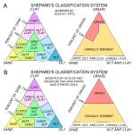
Those samples for which full grain-size data are available were also assigned classifications based on definitions found in Shepard (1954) as modified by Schlee and Webster (1967), Schlee (1973) and Poppe and others (2004). In displaying the lithologic descriptors, the general ranking principle of the main constituents (for example, gravel, sand) and modifying constituents (for example, sandy, silty) follows in order of decreasing coarseness. The sediment classification color assignment is represented by the following legend:

 
Sediment Classification
   

Red - sediment whose main phase is gravel (>50%); rocky bottom


Orange - sediment with significant amounts of gravel (>10%, but<50%)


Yellow - sediment whose main phase is sand without significant gravel or mud


Green - sediment with significant (>20%) sand, silt, and clay


Blue - sediments whose main phase is silt (>50%)


Purple - sediments whose main phase is clay (>50%)


Available overview maps of the sediment classes for several selected U.S. Atlantic East Coast regions are available below.  Maps are available in both JPEG image format and Adobe PDF.  To view files in PDF format, download a free copy of Adobe Reader.

  • The Atlantic Continental Margin IMAGE - PDF
  • Gulf of Maine - IMAGE - PDF
  • Mid-Atlantic/NY Bight - IMAGE - PDF
  • North and South Carolina (Carolina Trough) - IMAGE - PDF
  • Georgia and Florida (Blake Plateau Basin) - IMAGE - PDF
  • Gulf of Mexico - IMAGE - PDF
  • Puerto Rico - IMAGE - PDF
  • World Map - IMAGE - PDF


Accessibility FOIA Privacy Policies and Notices

USA.gov logo U.S. Department of the Interior | U.S. Geological Survey
URL: http://woodshole.er.usgs.gov/project-pages/sediment/visualization.html
Page Contact Information: Feedback
Page Last Modified: Tuesday, 30-Dec-2014 09:26:20 EST (GW)