
|
| U.S. Geological Survey Open-File Report 02-002 |
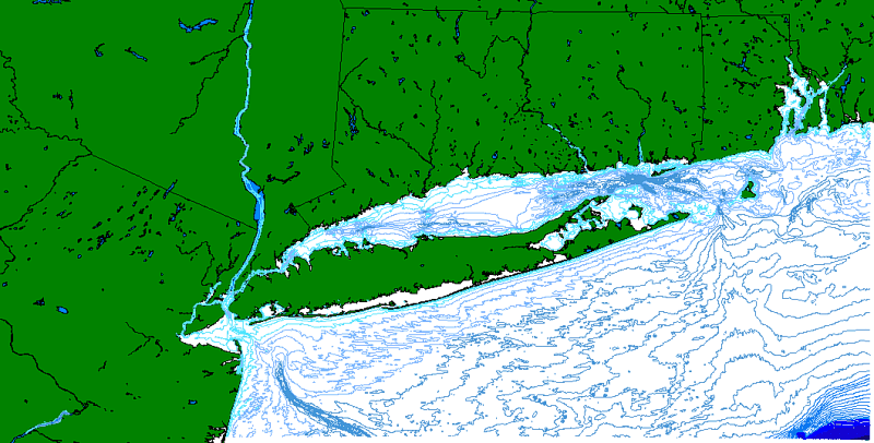
Schmuck, Eric, Unknown, LIS1992: 5 m Bathymetric Contours for Long Island Sound:.This is part of the following larger work.Online Links:
Poppe, Larry, and Paskevich, Valerie, 2002, Geologic Framework Data from Long Island Sound, 1981-1990: A Digital Data Release: U.S. Geological Survey Open-File Report 02-002, U.S. Geological Survey, Coastal and Marine Geology Program, Woods Hole, MA.Online Links:
This is a Vector data set. It contains the following vector data types (SDTS terminology):
Horizontal positions are specified in geographic coordinates, that is, latitude and longitude. Latitudes are given to the nearest 0.000000. Longitudes are given to the nearest 0.000000. Latitude and longitude values are specified in Decimal degrees.
The horizontal datum used is North American Datum of 1983.
The ellipsoid used is Geodetic Reference System 80.
The semi-major axis of the ellipsoid used is 6378137.000000.
The flattening of the ellipsoid used is 1/298.257222.
Sequential unique whole numbers that are automatically generated.
| Value | Definition |
|---|---|
| PolyLine |
Coordinates defining the features.
| Range of values | |
|---|---|
| Minimum: | 0 |
| Maximum: | 137.83 |
| Resolution: | .001 |
| Range of values | |
|---|---|
| Minimum: | -345 |
| Maximum: | -5 |
| Units: | meters |
| Resolution: | 1 |
U. S. Geological Survey, Coastal and Marine Geology Program
c/o Valerie Paskevich
Computer Specialist, GIS Coordinator
384 Woods Hole Road
Woods Hole, MA 02543-1598
USA
508-548-8700 x2281 (voice)
508-457-2310 (FAX)
vpaskevich@usgs.gov
These data can be used with geographic information systems (GIS) software to display geologic and oceanographic information for the U. S. Atlantic northeast. The data are to be used for illustrations and illustrative maps on scientific topics. They are intended for science researchers, students, policy makers, and the general public. There is NO ASSURANCE of their accuracy, completeness, or precision.
No additional checks for topological consistency were performed on this data set.
Are there legal restrictions on access or use of the data?
- Access_Constraints: None
- Use_Constraints:
- Although these data have been used by the U.S. Geological Survey, U.S. Department of the Interior, no warranty expressed or implied is made by the agency as to the accuracy of the data.
The act of distribution shall not constitute any such warranty, and no responsibility is assumed by the U.S. Geological Survey in the use of this data.
This information is NOT intended for navigational or legal purposes.
Any use of trade, firm or product names is for descriptive purposes only and does not imply endorsement by the U.S. Government.
Valerie Paskevich
U.S. Geological Survey
Computer Specialist
384 Woods Hole Road
Woods Hole, MA 02543-1598
USA
(508) 548-8700 x2281 (voice)
(508) 457-2310 (FAX)
vpaskevich@usgs.gov
Long Island Sound: lis1992.shp
Although this derived data set and its lineage dataset have been used by the USGS, no warranty, expressed or implied, is made by the USGS as to the accuracy of the data and/or related materials. The act of distribution shall not constitute any such warranty, and no responsibility is assumed by the USGS in the use of these data or related materials.
| Data format: | The seven ArcView shapefiles (lis1992.dbf, lis1992.shp, lis1992.shx, lis1992.sbn, lis1992.sbx, lis1992.avl, lis1992.prj) comprising the 1 meter bathymetric contours for Long Island Sound and an ASCII version of the metadata. in format ArcView shapefile (version 3.2) Size: 1.53 Kbytes |
|---|---|
| Network links: |
<http://woodshole.er.usgs.gov/openfile/of02-002/data/bathy/lis1992.zip> |
| Media you can order: |
DVD
(Density 4.75
Gbytes)
Note: The user must have a system with a DVD drive capable of reading an UDF standard DVD-R disk. To browse the information contained on this disk, the user must also have a current version of WWW browser available. The user must also have the software installed on their computer system capable to unzip the archived file.
|
Valerie Paskevich
U.S. Geological Survey, Coastal and Marine Geology Program
Computer Specialist, GIS Coordinator
384 Woods Hole Road
Woods Hole, MA 02543-1598
USA
508-548-8700 x2281 (voice)
508-457-2310 (FAX)
vpaskevich@usgs.gov