Skip USGS links group
U.S. Geological Survey - science for a changing world
CZM logo with link to CZM home page

Woods Hole Science Center

End of USGS links group

OFR 2005-1048 Home / Introduction / Geologic Setting / GIS Data Catalog / Bottom Photographs

Skip title; go to table of contents Skip title; go to table of contents

U.S. Geological Survey Open-File Report 2005-1048

Geological Interpretation of Bathymetric and Backscatter Imagery of the Sea Floor Off Eastern Cape Cod, Massachusetts
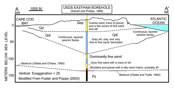

Figure 23

Figure 23: Interpretive cross section of the Eastham borehole.

Interpretive cross section modified from Foster and Poppe (2003) based on the USGS Eastham borehole. Cross section shows the lateral distribution of fine-grained glaciolacustrine deposits and that they extend beneath the outer Cape. See Figure 20 for location of cross section.


Skip footer Table of Contents; Go to Footer OFR 2005-1048 Home / Introduction / Geologic Setting / GIS Data Catalog / Bottom Photographs

Skip Navigation

Accessibility FOIA Privacy Policies and Notices

U.S. Department of the Interior | U.S. Geological Survey | Coastal and Marine Geology

URL: cmgds.marine.usgs.gov/publications/of2005-1048/htmldocs/figures/f23_ccewell.htm
Page Contact Information: CMGDS Team
Page Last Modified: Wednesday, 06-Dec-2017 12:35:15 EST