Skip USGS links group
U.S. Geological Survey - science for a changing world
CZM logo with link to CZM home page

Woods Hole Science Center

End of USGS links group
High-Resolution Geologic Mapping of the Inner Continental Shelf: Nahant to Gloucester, Massachusetts

Title Page / Table of Contents / List of Figures / Introduction / Maps / Data Collection/Processing / Interpretation / Acknowledgments / Appendix 1 / Appendix 2 / Appendix 3 / Appendix 4


Figure 3.5. Isopach map of total sediment thickness in the survey area. Figure 3.5. Isopach map of total sediment thickness in the survey area. Figure 3.5. Isopach map of total sediment thickness in the survey area.

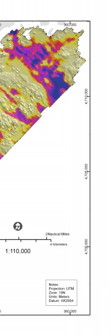
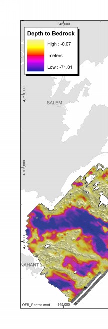
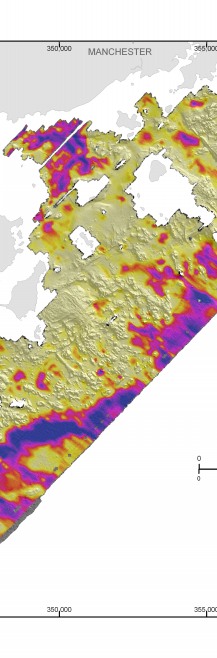
Figure 3.5. Isopach map of total sediment thickness in the survey area. Gridded values were interpolated from closely spaced seismic reflection profiles shown in figure 3.4.


Skip Footer Information
Skip Navigation

Accessibility FOIA Privacy Policies and Notices

U.S. Department of the Interior | U.S. Geological Survey | Coastal and Marine Geology

URL: cmgds.marine.usgs.gov/publications/of2005-1293/html/imagepages/fig3_5.html
Page Contact Information: CMGDS Team
Page Last Modified: Wednesday, 06-Dec-2017 12:46:00 EST