|
Long Bay, South Carolina, is a heavily developed coastal region that supports a large tourism industry. Local economies that depend on the health of the shoreline are adversely impacted by loss of property and property damage due to coastal erosion and storm events. Mitigation of coastal erosion in this region depends on the availability of sand resources. Earlier geological framework studies along the inner shelf of Long Bay have identified a large sand deposit oblique to the shoreline, oriented clockwise in the offshore direction (Baldwin and others, 2004 and http://pubs.usgs.gov/of/2004/1013/). This sand feature, which is approximately 10 kilometers long, 2 kilometers wide, and greater than 3 meters thick, possibly provides a source for beach nourishment material (fig. 4).
| 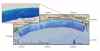 Figure 4. Map displaying the location of the shore-oblique sand feature located offshore of Myrtle Beach. Click on figure for large image in PDF format.
 |
|
|
River runoff and local winds provide the primary hydrodynamic forcing in this region (Atkinson and others, 1983; Lee and others, 1985). Freshwater input into Long Bay occurs via the Cape Fear, Pee Dee, North Santee, and South Santee Rivers. Southwesterly winds occur in the summer and are generally favorable for upwelling (Weber and Blanton, 1980). In the fall, the winds are northeasterly and are favorable for downwelling. These winds generate strong alongshore currents that can influence sediment transport on the inner shelf; however, the direct linkage of sediment transport between the nearshore and the inner shelf remains unknown.
This study was undertaken to understand some of the physical processes that control the transport of sediments in Long Bay. In particular, near the region of the offshore sand feature, the main objectives of the study were to:
- identify the processes that control the circulation of water and the residual transport of sediments on the inner shelf,
- identify the processes that are maintaining the presence of the offshore sand feature,
- identify linkages of sediment transport between the shoreface and the inner shelf, and
- quantify the control that the sand feature exerts on the nearshore conditions through changes in wave energy propagation characteristics.
A six month field program on the inner shelf of Long Bay provided detailed hydrodynamic and morphometric measurements required for meeting the objectives of this study. These measurements, obtained from October 2003 through April 2004, yielded information on water flow, sea level, conductivity, temperature, wave characteristics, near-bottom turbulence, suspended sediment concentrations, and sea floor bedforms (ripples). This report presents these observations.
|