
|
The multibeam bathymetric data from survey H11255 are shown in figure 4. Water depths within the survey area range from less than 18 m in its southeastern corner to over 36 m about 1 km north of the southwestern corner. The sea floor has a relatively smooth gradient that slopes gradually away both northward and westward from its southeastern corner. Farther westward, the sea floor within the survey area funnels southwestward into an elongate east-west bathymetric low. This bathymetric low, referred to as the axial depression (Knebel and Poppe, 2000), extends from the survey area, south of Stratford Shoal Middle Ground, and into the next basin. Eastward, this depression broadens and shallows and deflects south of the bathymetric high in the southeastern corner of the survey area where it abuts and extends past the tip of the Roanoke Point Shoal. Except for the axial depression, pre-existent bathymetric data (DiGiacomo-Cohen and others, 1998) show that the sea floor shallows eastward, northward, and northwestward of the survey area.
High-resolution seismic-reflection profiles across the axial depression in the vicinity of the survey area (fig. 5, fig. 6, and fig. 7) show that this bathymetric low results from a thinning of the Holocene marine section (Needell and others, 1987; Poppe and others, 2002a). The marine unconformity, which separates the Holocene section from the Pleistocene deposits, remains relatively flat across the axial depression, suggesting that the underlying glaciolacustrine units are not affected. Whether this thinning is due to erosion or simply a lower sedimentation rate is uncertain, but modeling has shown that bottom currents are stronger within this depression and locally exceed 20 cm/sec (Signell and others, 2000). These seismic profiles also show that as the depression broadens and shallows eastward, the Holocene section thickens.
Two semi-enclosed, elongate depressions are centered near 41°2.95'N, 72°43.5W and 41°2.25'N, 72°41.5'W. These depressions are small (about 1 km and 1.8 km, respectively), narrow (less than 0.25 km wide), trend about 80°, and extend as much as 2 m below the surrounding sea floor. Borders of the elongate depressions are steeper and better defined on their sides and eastern ends. |
Click on figures for larger images.
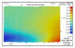 |
Figure 4. Digital terrain model (DTM) from survey H11255.
|
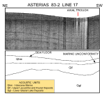 |
Figure 5. Subbottom profile from line 17.
|
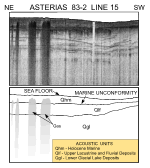 |
Figure 6. Subbottom profile from line 15.
|
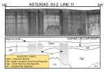 |
Figure 7.Subbottom profile from line 11.
|
|
