Woods Hole Science Center
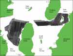
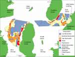
Surficial Geology in Central Narragansett Bay, Rhode Island: Interpretations of Sidescan Sonar and Multibeam Bathymetry
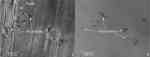
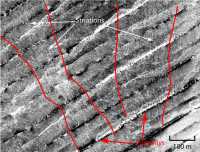
Tonal changes in the sidescan sonar mosaic help determine sediment distribution in the study areas (fig. 5). Light tones indicate high backscatter caused by generally coarser grained sediment or a hard bottom; dark tones indicate low backscatter caused by generally finer grained sediment or an acoustic shadow. Speckled backscatter, produced by individual high-backscatter targets with low-backscatter shadows, indicates rocky or boulder areas. In addition to sediment distribution, tonal changes show a variety of anthropogenic objects, including pipelines or cables, shipwrecks, piers, and bridge pilings (fig. 6). Tonal changes are generally gradual and mapped borders are inferred. Some abrupt tonal changes, such as those along the northern edges of the West Passage study area, are artifacts of the data processing. Areas of low backscatter occur throughout much of the study area. In West Passage, they are located in the northern and central parts of the study areas and in the deeper troughs to the south. In East Passage, low backscatter characterizes the sea floor southwest of Prudence Island, in the trough between Prudence and Dyer Islands and to the northeast of Dyer Island. These regions of low backscatter exist in areas of broad, gently sloping bathymetry or deeper parts of the study areas. Areas of high backscatter are mainly located nearshore, in shallow water. In West Passage, high backscatter characterizes the sea floor south of Quonset Point stretching southward to Plum Point. It also extends into part of the trough to the east of Plum Point. There are patches of high backscatter along the western side of Conanicut Island. In East Passage, high backscatter is located to the north and south of Dyer Island and along the southeastern side of Prudence Island. Rocky areas, like the areas of high backscatter, are mainly located nearshore. In West Passage, rocky areas are located along the western coast of Conanicut Island and are scattered throughout and around the high backscatter areas. In East Passage, rocky areas exist along the southeast coast of Prudence Island, around Dyer Island, and along the western coast of Aquidneck Island. These rocky areas consist of speckled backscatter as well as high backscatter spots and associated low backscatter shadows caused by boulders. The latter pattern exists in areas of both high and low backscatter. An area of mottled tones exists in the sidescan sonar mosaic around the edges of the low backscatter areas south of Prudence Island (fig. 4 and fig. 6). The mottling generally corresponds to varied depths in the bathymetry where irregularly shaped mounds and depressions exist and is probably the result of the microtopography. Isolated circular depressions in the sea floor, up to about 40 m wide, are apparent in the sidescan sonar imagery and bathymetry (fig. 6 and fig. 7). These depressions are primarily located in regions of low backscatter, but are also occasionally found in areas of moderate and high backscatter. In West Passage, a group of depressions is situated to the northeast of Plum Point. In East Passage, they are spread out south of Prudence Island and near Little Harbor Landing. A cluster of depressions exists in the trough southeast of Prudence Island. These depressions appear to be pockmarks formed by biogenic gas escaping from the subsurface through overlying muddy sediment. McMaster (1984) used high-resolution seismic-reflection profiles to map gas-bearing sediments in East Passage, coinciding with areas where many of the pockmarks visible on our multibeam and sidescan sonar data occur. However, there are also depressions in the West Passage study area outside of the regions where gaseous sediments have been reported and within areas characterized by sandy and gravelly sediment in addition to muddy ones. Although pockmarks can form outside gas fields from the migration of gas along permeable strata (Rogers and others, 2006) and organic-rich muddy sediments may underlie coarser surficial sediments, the cause of these depressions in sandy and gravelly sediments is unknown. Two zones of linear striations of relatively high backscatter, which are located within an area of moderate backscatter, are present in the westernmost region of the West Passage study area (fig. 8). They are oriented down-slope, funneling into a bathymetric low, most likely indicating drainage of the embayment to the west during tidal cycles. We interpret these features, which show no resolved relief in the bathymetry data, to be down-slope pathways by which sediment is remobilized and transported into deeper environments. Anthropogenic features, including pipelines or cables, shipwrecks, piers, and bridge pilings, are visible in the sidescan sonar imagery. Pipelines and cables are distinguished as two parallel lines of high and low backscatter. Four pipelines or cables are visible in the north and central parts of study area in West Passage and three are located in the trough in East Passage. There are two shipwrecks located to the southeast of Prudence Island. Two piers in the study area are visible in the sidescan sonar imagery as angular high and low backscatter. One is located on the southeast side of Prudence Island and the other, Little Harbor Landing, is on Aquidneck Island. Pilings for the Jamestown Bridge are shown in the sidescan mosaic as blocky areas of high backscatter and an acoustic shadow of low backscatter. |