USGS Coastal and Marine Geology Program
Geophysical Mapping of Oyster Habitats in a Shallow Estuary; Apalachicola Bay, Florida
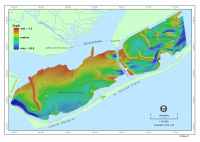
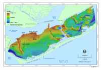
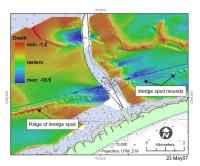
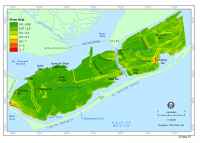
Estuary-Floor MorphologyApalachicola Bay is a broad shallow estuary that contains four subareas: East Bay, St. Vincent Sound, Apalachicola Bay, and St. George Sound (fig. 4). Navigation charts # 11402 and # 11404 (NOAA, 1996; 2000) show that East Bay, the area adjacent to the Apalachicola River delta, is the shallowest part of the estuary, having no depths greater than 2 m. Much of St. Vincent Sound is also less than 2 m deep, but a narrow 5-7 m deep trough extends approximately 6 km eastward from Indian Pass. The data collected during this survey cover the Apalachicola Bay and St. George Sound sections of the estuary, which are its deepest parts. No data were collected in East Bay or St. Vincent Sound. Within these areas, the estuary has a generally smooth floor that increases in depth southward from 2 m in the north to 4 m in the south (fig. 4 and Mapsheet 1). Depths locally exceed 15 m on the shoreward side of West Pass. St. George Sound is the deepest part of the estuary, and much of its floor is smooth, with depths of 3 to 4 m. Depths increase to 4 - 6 m in the eastern part of this sound, where the sea floor is more irregular and shaped into a series of broad, low-relief depressions and mounds. Deviations from the smooth, regional, bathymetric pattern are caused by three forms of shoals: shore-attached lobate shoals, linear shoals, and small shoals. Shoal locations and names, identified by the Apalachicola Bay National Estuarine Research Reserve, or from NOAA navigation charts (NOAA, 1996; 2000), are shown on figure 6. Lobe-shaped shoals extend northward from St. George and Little St. George Islands into the southern side of the bay. The largest are Pelican Bar, in St. George Sound, and Cedar Point and Higgins Shoals, in Apalachicola Bay. Higgins Shoal is located shoreward of a former inlet on Little St. George Island that was open in 1860 (fig. 7). It appears to be the remnant of a flood-tidal delta that formed while the inlet was active. The other lobate shoals, located along the north side of the islands, may have also originated in flood-tidal delta settings. Linear shoals exceeding 4 km in length are found in St. George Sound and Apalachicola Bay (fig. 6). All of these shoals trend roughly perpendicular to the long axis of the bay, and four of the six have one end attached to the shore. The largest, St. Vincent Bar, is located at the western end of Apalachicola Bay. It extends southeastward from the northeastern tip of St. Vincent Island to within 1.5 km of Little St. George Island. A deep channel extends eastward from West Pass, separating the southern tip of St. Vincent Bar from Little St. George Island (fig. 4). The bar is 7 km long, 0.7 - 1.3 km wide, and rises to within 0.5 - 1 m of the bay surface. Other large linear shoals include Norman's Bar, which is separated from Hotel Bar by the Intracoastal Waterway, Cat Point Bar, East Hole Bar, Platform Bar, and Porter's Bar. Cat Point Bar extends southeastward from the eastern side of Cat Point and connects with Platform Bar. East Hole Bar extends northwest from St. George Island and merges with Cat Point Bar (fig. 6). This complex of bars forms a nearly continuous string of shoals across the bay that is only broken by two narrow, deeper gaps. The channel between Pelican and Platform Bars exceeds 6 m depth. The channel that separates Cat Point Bar from East Hole Bar was not completely surveyed by this study, but, where surveyed, the channel reaches 4.9 m immediately west of the Bryant Patton Bridge at its northwestern end and 3.2 m at its southeastern end near Platform Bar. The navigation chart shows that the section not surveyed by this study reaches depths between 1.5 and 2 m (NOAA, 1996). The Intracoastal Waterway is dredged through East Hole Bar to depths exceeding 4 m (fig. 8). The easternmost of the large linear shoals is Porter's Bar, which extends from the northern shore of St. George Sound southeastward for 4 km. The crests of the linear shoals rise to within 1 m of the bay surface, with the exception of Norman's Bar, whose crest is 2 - 2.5 m deep. The linear shoals are unique because they are asymmetrical, with steeper, west-facing sides (fig. 9). The small shoals are less than 1.5 km in length, are isolated from the shoreline, and have a variety of orientations (fig. 6). One cluster of these shoals, located east of St. Vincent Bar, includes Cable Lumps, North Spur, Sugar Lumps, and West Lumps. A second cluster lies south of the John Gorrie Bridge. It includes a discontinuous string of linear to circular mounds that lie immediately north of Norman's Bar and the East Lumps. Two small shoals, Green Point Bar and an unnamed shoal, are found east of Porter's Bar. The small shoals have varied orientations. In the eastern part of St. George Sound, Green Point Bar and the unnamed shoal trend northwest-southeast, while shoals north of Norman's Bar trend north-south, and shoals in the western part of Apalachicola Bay, West, Cable, Sugar Lumps, and North Spur, display no dominant orientation. These smaller shoals have less relief than the large linear shoals, and their crests are generally deeper than 2 m. Most of the small shoals are asymmetrical, with steeper, west-facing sides (fig. 9), but several symmetrical shoals lie in the central part of Apalachicola Bay, between Norman's Bar and the John Gorrie Bridge. A pronounced, anthropogenic feature of the bay floor is the Intracoastal Waterway. This dredged channel starts near the eastern edge of the survey area, weaves around the shoals in St. George Sound, cuts across East Hole Bar, and extends westward to the central part of Apalachicola Bay, where it turns north and leads to the mouth of the Apalachicola River (fig. 4). The channel is 3 - 5 m deep along much of its length, and the dredge spoils deposited along its southern side are clearly visible in figure 6. Along some sections of the channel, the spoils form a continuous ridge with a crest as shallow as 1.7 m, while in other areas, they form discrete, circular mounds that are less than 200 m in diameter with crests 1.9 - 3.5 m deep (fig. 8). |
Click on figures for larger images and complete captions.
|
![]() Title |
Figures |
1-Introduction |
2-Data Collection and Processing |
3- Geologic Interpretation |
4-References |
5-Maps |
Spatial Data |
Acknowledgments
Title |
Figures |
1-Introduction |
2-Data Collection and Processing |
3- Geologic Interpretation |
4-References |
5-Maps |
Spatial Data |
Acknowledgments