USGS Coastal and Marine Geology Program
Geophysical Mapping of Oyster Habitats in a Shallow Estuary; Apalachicola Bay, Florida
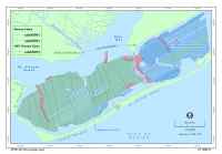
Seismic-Reflection DataHigh-resolution, seismic-reflection profiles were collected from both the Rafael and IRIS along 2,372 km of track line, which were spaced ~ 75 - 100 m apart (fig. 3). During the first seven survey days of the 2005 cruise aboard the Rafael (Julian Days 76-83), seismic data were acquired using a Knudsen 320b chirp system (3.5). The remaining seismic data, collected from both survey vessels during 2005 and 2006, were acquired using Edgetech FSSB 424 (4-24 kHz) systems. The Knudsen was used initially because of easier side-mount deployment from R/V Rafael in shallow water environments. However, profile comparisons showed that the Edgetech FSSB-424 provided higher-quality data, so it was used throughout the subsequent survey periods. The seismic data from the Rafael were acquired as SEG-Y files using Delph Seismic+ in 2005 and SBLogger in 2006. IRIS data were acquired in .jsf format using jstar, then converted to SEG-Y. All seismic data were processed using SIOSEIS (http://sioseis.ucsd.edu/) and Seismic Un*x (http://www.cwp.mines.edu/cwpcodes/) to produce jpg images of each of the seismic profiles. |
Click on figure for larger image.
|
![]() Title |
Figures |
1-Introduction |
2-Data Collection and Processing |
3- Geologic Interpretation |
4-References |
5-Maps |
Spatial Data |
Acknowledgments
Title |
Figures |
1-Introduction |
2-Data Collection and Processing |
3- Geologic Interpretation |
4-References |
5-Maps |
Spatial Data |
Acknowledgments