USGS Coastal and Marine Geology Program
Geophysical Mapping of Oyster Habitats in a Shallow Estuary; Apalachicola Bay, Florida
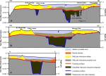
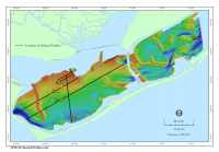
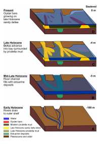
Subsurface GeologyThe late Pleistocene and Holocene history of the northern Florida shelf region has been generally described by Schnable and Goodell (1968); Schmidt (1984); Otvos (1985); Donoghue (1992; 1993); Donoghue and White (1995); McKeown and others (2004); Gardner and others (2005). The dense grid of chirp profiles collected during this survey provides a refined view of Apalachicola Bay's Holocene history specifically. Facies interpreted from the seismic-reflection profiles are shown in figure 11, their regional distribution is shown in figure 12, and the profile locations are shown in figure 13. A conceptual model showing the evolution of the bay since the last lowstand of sea level is shown in figure 14. During several Pleistocene lowstands of sea level, the ancestral Apalachicola River incised a large valley southward across the region, depositing a series of well-developed deltas on the middle and outer shelf, south of the present location of the estuary (fig. 14A). This valley was cut to depths of approximately 15 m (20 ms) into Pleistocene and earlier sediments beneath the bay (Donoghue, 1992; fig. 12). As sea level rose during the Holocene, the section of the valley underlying the outer shelf was filled during the Early Holocene, and the section underlying Apalachicola Bay was filled by the Middle-to-Late Holocene (fig. 14B). The acoustic facies filling the valley are as much as 8 m (13 ms) thick and consist of parallel continuous reflections (fig. 11). These deposits are interpreted to be fine-grained, estuarine deposits. A well-defined horizon, interpreted to be the flooding surface associated with submergence of the bay during the Late Holocene (fig. 14B), marks the top of this acoustically laminated facies (fig. 11). Under much of the bay, this horizon can be traced away from the paleo-river valley onto adjacent, subsurface, topographic highs (fig. 12). In the western part of St. George Sound and most of Apalachicola Bay, east of St. Vincent Bar, the flooding surface is buried by younger sediment delivered by the Apalachicola River. Chirp profiles show that the youngest deposits in the bay compose a delta system that is overlain by modern prodelta mud that continues to be supplied by the Apalachicola River (fig. 12). The delta system developed in the central part of the bay (fig. 14C) comprises sandy delta lobe facies with muddy prodelta deposits between and beyond the sandy lobes. The sandy parts of this delta system produce a highly-reflective, irregular surface in the chirp profiles, which stands in relief, relative to the surrounding muddy deposits, displaying a weakly-reflective, smooth surface (fig. 11). The shallow, sandy parts of the delta are organized into several fingers that protrude into the bay (fig. 14C). The tops of most of these fingers are less than 4 m below present sea level, while the adjacent lows are 4 - 5 m deep. The distribution of the shallow ridges in the seismic dataset suggests they represent two sets of delta lobes that advanced into the estuary. One set underlies the western part of Apalachicola Bay covering the area under and immediately east of St. Vincent Bar, and the second underlies the eastern part of the bay under and east of Norman's Bar (fig. 12A, B). The two sets of delta lobes suggest two separate deltas. Donoghue and White (1995) report that the Apalachicola River shifted its course approximately 6,000 years ago. Initially, the river drained into the estuary west of the present town of Apalachicola and then shifted eastward to its present course. Perhaps the two delta complexes were deposited before and after the eastward shift documented by Donoghue and White (1995). The youngest unit is the modern, prodelta mud that overlies the mid-to-Late Holocene delta and prodelta deposits. Its surface is the present estuary floor (fig. 11). This unit is as much as to 2.5 m thick adjacent to the mouth of the Apalachicola River, but thins to the east and west where it onlaps and locally buries the older delta deposits (fig. 12). Along the southern edge of the bay it onlaps the back of the barrier island system (fig. 12C). The areal extent of this unit is the same as the mud unit identified in the sidescan-sonar imagery, and it is interpreted to be prodelta mud deposits associated with the modern Apalachicola River system (fig. 14D). |
Click on figures for larger images and complete captions.
|
![]() Title |
Figures |
1-Introduction |
2-Data Collection and Processing |
3- Geologic Interpretation |
4-References |
5-Maps |
Spatial Data |
Acknowledgments
Title |
Figures |
1-Introduction |
2-Data Collection and Processing |
3- Geologic Interpretation |
4-References |
5-Maps |
Spatial Data |
Acknowledgments