Woods Hole Science Center
Geologic Interpretation and Multibeam Bathymetry of the Sea Floor in the Vicinity of the Race, Eastern Long Island Sound
|
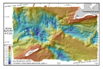
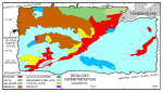
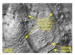
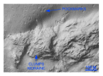
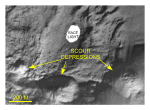
The detailed multibeam bathymetry and subbottom seismic-reflection data presented here yield a new geologic perspective and reveal previously unknown details of a dynamic sea floor surface. Extensive tidal action over the past 15,000 years has removed much of the glacial and younger sediment that once filled eastern Long Island Sound and northwestern Block Island Sound (Lewis and Stone, 1991). Based on geomorphological and acoustic characteristics of the complex topography resulting from this erosion, we have been able to interpret the exhumed glacial features and to delineate the ongoing sedimentary processes. Features identified on the bedrock surface exposed within the study area can be correlated with those of onshore formations. The northwest-southeast bedrock trends described in the study area (fig. 14) are similar to glacially smoothed bedrock ridges that trend between N 15° and N 20° W on land immediately west of the Thames River. These elongate ridges, which are similar in size, orientation, and morphology to their inferred offshore counterparts, parallel the interpreted direction of ice movement as shown by grooves and striations (Goldsmith 1962; fig. 2). The second set of ridges that trend northeast-southwest (fig. 14) are similar to features on the east side of the Thames River, which trend between N 65° E and N 80° E, and parallel the strike of foliation and the orientation of some jointing of the Avalonian anticlinorium (fig. 2). These ridges and their offshore counterparts were probably formed by glacial plucking, and resemble strike ridges formed in dipping layered rock. Together, these lineations show that the effects of glaciation on the bedrock continue offshore under Long Island Sound. The dominant glacial features in the study area are the northeast-trending Harbor Hill-Orient Point-Charlestown moraine, the Clumps moraine, and another smaller, previously unknown, recessional moraine south of Fishers Island (fig. 10). We interpret the newly identified morainal ridge to be a segment of one of the less prominent recessional moraines that lie between and to the north of the two major moraine belts. Sirkin (1982) refers to a "recessional moraine envelope" that crosses Shelter Island and northern Gardiners Island. We infer that the newly recognized Block Island Sound ice position is a northeastward extension of this envelope. A streamlined sediment ridge overlying bedrock is interpreted to be a drumlin, and a south-trending sinuous ridge and an isolated bathymetric high associated with the largest moraine are interpreted to be an esker and kame, respectively. Exposed remnants of fine-grained glaciolacustrine sediments are scattered throughout the study area, and part of the Thames River glacial delta is visible along its northern edge. Gas-charged sediments have been previously reported in this delta (Lewis and Needell, 1987) and pockmarks and gas-charged sediments have been reported nearby in Fishers Island Sound (Poppe and others, 1998). The source of the methane in these sediments is uncertain, but it probably originates from organic matter trapped in the rapidly deposited sediments of the delta. In any case, the asymmetry of many of the depressions is evidence that modern currents are at least partly responsible for the character and maintenance of these features (fig. 15). The strong tidal currents have produced large bathymetric depressions adjacent to the Race that exceed 100 m in depth (fig. 9). Degradational processes that caused these scour depressions include seabed erosion and mass-wasting, and effects of both processes are visible on the DTM as erosional outliers and slump blocks. Tidal flow in the middle of the Race commonly exceeds 2 m/s, and constriction of the gross tidal flow leads to even higher current speeds off promontories, such as Race Point, and the formation of characteristic eddy patterns of great competence (Pingree, 1978; Poppe and others, 1999; Signell and others, 2000). Bottom samples and video images from in and near the Race suggest that gravel armors much of the bottom (Poppe and others, 2000). However, gravel transported by currents may also be an abrading agent. As the swirling turbulent water in these fast eddies suspends and rolls gravelly sediment around in the depressions, impacts cause abrasion and the tearing of clasts from the walls and floor. In this manner, continued erosion has created and enlarged the three large circular scour depressions that flank Race Point (fig. 21). Similar features, albeit on a much smaller scale, are the cylindrical cavities or potholes found cut in stream beds. Asymmetry of transverse sand waves, barchanoid dune orientation, and scour around isolated boulders and a shipwreck indicate that net transport is primarily toward the west, and into Long Island Sound across the northern part of the study area, but largely toward the east and out of the sound across the southern part. This pattern of sediment movement supports previously untested bottom circulation and transport models produced for eastern Long Island Sound (Welsh, 1993; Signell and others, 2000; fig. 11). |
Click on figures for larger images.
|