Woods Hole Science Center
Geologic Interpretation and Multibeam Bathymetry of the Sea Floor in the Vicinity of the Race, Eastern Long Island Sound
|
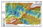
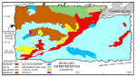
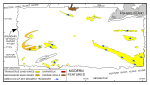
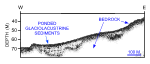
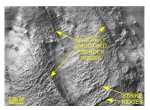
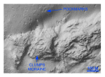
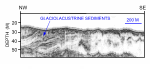
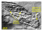
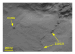
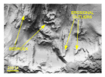
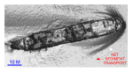
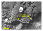
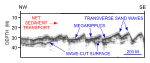
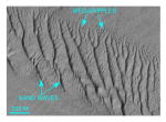
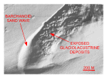
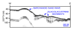
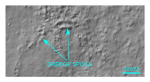
The multibeam bathymetric data (fig. 9) show distinctive patterns in the morphology of the sea floor that can be correlated with underlying, seismically detected geologic units, which appear to be partly or completely exposed in the study area, and with the effects of modern processes. These correlations have been used to construct interpretive maps (fig. 10, fig. 11). These maps show where exposed crystalline bedrock, coastal-plain, moraine, glaciolacustrine, and glaciodeltaic deposits are inferred to crop out or subcrop. It also documents the effects of strong tidal currents, which include intense scour and coarse bedload transport, and the presence of gas-charged sediments. Isolated erosional remnants of younger deposits, lag deposits, and pockets of mobile sediment not of sufficient size to be distinguished are inferred to locally overlie and to be interspersed with mapped units throughout the survey area. The main seabed features identified in the course of this study are described below. Ice-sculptured bedrockAvalonian bedrock is inferred to predominate in two fairly large areas in the northwestern part of the study area (fig. 10). Characteristics that were used to delineate the bedrock include the presence of an irregular seismic reflection inferred to be acoustic basement, cropping out or subcropping so as to influence the morphology of the sea floor, the absence of a related pattern of "spiked" reflections indicative of boulders on the bottom, and an associated pattern of distinctive parallel ridges on the DTM (fig. 12, fig. 13, and fig. 14). The multibeam data reveal two sets of distinctive parallel ridges that are similar to terrestrial bedrock features of the adjacent Connecticut coast. One set trends northwest-southeast (~N 15° W). The second set of ridges trends northeast-southwest (~N 60-70° E). Coastal-plain strata and older driftAs pointed out above, coastal-plain strata of late Cretaceous age are reported to overlie the south-southeast dipping bedrock surface in the vicinity of Fishers Island. Although these unconsolidated to semi-consolidated gravels, sands, silts and clays are often difficult to distinguish from glacial drift in seismic reflection profiles, we used the multibeam data to differentiate coastal-plain strata from moraine on the basis of two criteria: the absence of surface boulders, and the absence of minor ridges that parallel the overall trend of the mapped moraines. On this basis, we mapped exposed or subcropping coastal-plain strata adjacent to, and north of the Harbor Hill-Roanoke Point-Charlestown moraine (fig. 10). A small, elongate ridge in the west-central portion of the survey area overlies bedrock, is more streamlined than the inferred coastal-plain outlier to the east, and is not bouldery (fig. 10). The northwest-southeast orientation, lack of internal rhythmic layering, smoothness, and relatively small size of this feature suggest that it may be older glacial drift in the form of a drumlin. MorainesThree recessional end moraines are visible on the DTM (fig. 9, fig. 10). The largest, the Orient Point-Fishers Island segment of the Harbor Hill-Roanoke Point-Charlestown moraine, bisects the study area from southwest to northeast. Great Gull Island, Fishers Island, and the submerged ridge between them are formed by this moraine. Along the submerged ridge, the presence of surface boulders and small ridges parallel to the trend of the overall feature are inferred to indicate exposures of morainal deposits. South of Fishers Island along the east side of the study area, a previously unrecognized, southwest-northeast-trending morainal ridge has been exposed by erosion of the surrounding lake clay. This ridge exhibits smaller parallel ridges along its trend but appears to be more bouldery on its landward side than to the east. This textural phenomenon has also been documented farther to the west, in Long Island Sound, where lacustrine fans occur along former ice positions in glacial Lake Connecticut (Stone and others, 2005). The least prominent end moraine on the DTM, the Clumps moraine, is visible immediately west of Fishers Island (fig. 15). This moraine, which lies immediately north of, and locally abuts the Harbor Hill-Roanoke Point-Charlestown moraine, trends to the northeast, where it controls much of the bathymetry in the central and southern parts of Fishers Island Sound (Lewis and Stone, 1991; Poppe and others, 1998). Glaciolacustrine sedimentsErosional remnants of a seismic facies characterized by finely laminated, rhythmic, parallel internal reflectors that drape the underlying topography are exposed at three main locations (fig. 10, fig. 16). The largest exposure of this facies occurs along the northern wall of a depression southeast of Valiant Rock. There, angular slump blocks demonstrate the cohesive nature of these fine-grained sediments (fig. 17). There are other exposures along the western edge of the study area in Long Island Sound, and adjacent to the southern flank of the Fishers Island moraine segment in northwestern Block Island Sound (fig. 10). Numerous smaller exposures of this facies are also preserved within isolated bedrock lows in the northwestern part of the study area (fig. 13). Based on their seismic character and samples from coring studies (Bertoni and others, 1977; Poppe and others, 2002), we interpret these deposits to be varved, muddy, glaciolacustrine sediments that record deposition in Glacial Lake Connecticut northwest of the Race, and in other pro-glacial lakes that were present in Block Island Sound. Glaciodeltaic depositsA wedge of sediment laps over the northern flank of the Clumps moraine (fig. 9, fig. 10, fig. 15). This deposit has a distinctive seismic signature typified by seaward-dipping, oblique-tangential reflections in progradational clinoform configurations on seismic records that were run perpendicular to the Connecticut coast, and by the presence of gas-charged sediment (Lewis and Needell, 1987). We consider these seismic reflections to represent deltaic foreset and bottomset facies, and that this deposit is a remnant of the Thames River glacial delta, an ice-marginal deltaic deposit that prograded into Glacial Lake Connecticut (Lewis and Stone, 1991). Kame and eskerA sinuous, somewhat discontinuous ridge extends about 1.3 km southward from the Harbor Hill-Roanoak Point-Charlestown moraine immediately east of Great Gull Island (fig. 18). Near the moraine, this ridge is about 60 m wide, extends about 3 m above the surrounding sea floor, and has a hummocky crest. This ridge also progressively tapers, decreases in height, and smooths southward. We interpret this feature to be an esker, and to represent glaciofluvial deposition in contact with (i.e., beneath) stagnant ice (Banerjee and McDonald, 1975). A flattened broadening at its terminus may also represent an esker fan, and its orientation suggests that the general drainage in this area during its formation was toward the south. This feature probably owes its preservation through the Holocene transgression and modern current regime to a coarse gravelly composition and/or shelter provided by the east northeast-trending bathymetric high immediately to the south, which seismic profiles suggest may be composed of glacially reworked glaciodeltaic or glaciolacustrine sediments. In any case, this interpretation suggests that stagnant ice remained, at least locally, north of this bathymetric high during formation of the Harbor Hill-Roanoak Point-Charlestown moraine. An isolated conical bathymetric high is present about 0.7 km west of the ridge described above (fig. 18). We interpret this feature, which is approximately 70 m wide and 2.5 m high, to be the remnants of a kame. Kames are associated with eskers, and are generally considered to be another stagnant ice-contact deposit formed by the accumulation of glaciofluvial debris in a fissure or hole in the ice (Garner, 1974). As the ice melts, the debris collapses to form these mound-like features. ScourStrong tidal currents have scoured and redistributed much of the glacial and younger sediment in easternmost Long Island Sound (Lewis and DiGiacomo-Cohen, 2000). The intensity of this scour is evidenced by the large depressions adjacent to Valiant Rock, which in places now exceed 100 m in depth. The degradational processes associated with this scour include both erosion and mass-wasting, and the effects of both processes are visible in the multibeam data (fig. 9). Erosional outliers appear as elongate wedge-shaped bathymetric highs, with apexes that point upstream into the current and into constricted parts of the Race. Examples of erosional outliers of exposed coastal-plain strata occur immediately west-southwest of Valiant Rock (fig. 19). Processes associated with mass-wasting are best exemplified by the conspicuous slump deposit located along the northern edge of the scour depression southeast of Valiant Rock (fig. 17). Seismic data show that the beds in this area are composed of glaciolacustrine sediments (fig. 16). Presumably, these layered strata contain alternating non-permeable cohesive and permeable non-cohesive beds that form weak planes, allowing the sediments to break into blocks as they move downslope in the strong currents. The upper surfaces of the blocks are covered by asymmetrical sand waves that suggest transport is toward the southeast and away from the Race. Whereas a sharp erosional contact borders the northern edge of this feature, a 5-m high pile of excavated material is present on its eastern end. Elsewhere, tidal current-related scour is evidenced by the depressions around isolated boulders west of Great Gull Island, and around the shipwreck located about 1.2 km east-southeast of Valiant Rock (fig. 20). The strong oscillatory nature of the tidal currents is also illustrated by the three large circular scour depressions that flank Race Point (fig. 21). These rounded depressions are 130 - 380 m wide and 10 - 15 m deep. Sand wavesAt least 13 separate fields of large-scale bedforms containing both giant sand waves and megaripples are present in the study area (fig. 9, fig. 11). Nine fields were identified in western Block Island Sound, and four were found in easternmost Long Island Sound. These fields reflect the strength of the bottom currents, and can be used to indicate directions of net sediment transport (Ludwick, 1972). In general, most of the fields in the northern part of the study area exhibit sand-wave asymmetry that indicates net transport is toward the west into Long Island Sound. Most of the fields in the southern part of the study area exhibit sand-wave asymmetry that indicates net transport is toward the east and out of the sound. Our chirp acoustic data collected along adjacent lines during opposite tides show that gross sand-wave asymmetry does not change orientation with the tide (fig. 22). Whether this tidal independence of large bedform orientation is due to the spatial distribution of residual currents, or to an asymmetry of current velocities is uncertain. The most areally extensive sand wave field covers a well-defined, elongate, roughly 4-km² patch that extends from near Valiant Rock, the isolated bathymetric high in the middle of the Race, to the southeastern corner of the study area in western Block Island Sound where the field widens significantly (fig. 9, fig. 11). The modern surficial sand sheet that comprises the field is relatively thin (1-5 m in the troughs between the sand waves), and overlies an irregular wave-cut surface on post-glacial fluvial and estuarine sediments (Needle and Lewis, 1984; fig. 22). The sand waves in this field can be divided into two distinct areas based on morphology, and crests of the sand waves bifurcate at the contact between these areas. The sand waves along the southern edge, and throughout most of the southern part of the field are formed in gravelly sand (Poppe and others, 2000), and generally increase in both height and wavelength toward the southeast. Crest-to-trough heights there reach 7.85 m, and wavelengths, although irregular, average more than 150 m and can exceed 180 m (fig. 22, fig. 23). The sand waves in this part of the field are asymmetrical with slip faces that are oriented toward the southeast and have relatively straight to smoothly sinuous crests. Stoss slopes of the sand waves in this part of the field vary in the range 13-15°. Slip faces are steeper, averaging 19-23°. This asymmetry suggests a flow-transverse crest orientation, and net sediment transport toward the southeast. Megaripples, which mimic the asymmetry of the sand waves, are ubiquitously present on the stoss slopes and between the sand waves. The presence of these megaripples on the sand waves suggests that transport is active, and that the sand waves are propagating under the present hydraulic regime (Dalrymple and others, 1978; Reineck and Singh, 1980). Conversely, sand waves in the northwestern part of this field are more regularly spaced, but have average heights of less than 2 m and spacings of less than 24 m. Although some of the sand waves in the northwestern part of the field are symmetrical, most are asymmetrical with slip faces oriented toward the northwest. Sand wave asymmetry indicates that transport here is toward the northwest, and into Long Island Sound. Three large barchanoid sand waves occur northwest of Great Gull Island (fig. 9, fig. 11, fig. 24). These waves, which typically form in currents that are unidirectional, appear as crescent-shaped features in planar view, are convex westward, and partially overlap. This overlap appears to have caused an asymmetry that results in features with extremities (horns) of different length. Crescent width measured from the tip of the shortest extremity to the tip of its opposing side at the middle of the barchanoid sand wave approaches 970 m. Inasmuch as the horns of barchanoid dunes extend down current because they migrate faster than the main body (McKee, 1966), the morphology of these waves indicates a net eastward transport of sediment into the Race. Asymmetry of straight-crested sand waves, which are present south of the middle barchanoid sand wave and on the southern flank of the southern barchanoid sand wave, and of scour marks around nearby boulders also indicates net eastward transport. High-resolution seismic-reflection data show that the barchanoid waves reach heights of around 7 m over the sea floor on their up-current (western) sides (fig. 25). The seismic data also indicate that the stoss and slip faces have similar slopes and that these features, if mobile, are prograding over exposed glaciolacustrine sediment. PockmarksNumerous circular to oblate depressions are concentrated in a roughly 8.6-km² area north of the Clumps moraine off the western tip of Fishers Island (fig. 9, 15). The depressions are typically 5-6 m in diameter and extend about 0.2-0.3 m below the surrounding sea floor, but individual depressions can reach 24 m in diameter and 1.1 m in depth. At several places the depressions overlap, forming larger depressions that exceed 50 m across. We interpret these features to be pockmarks that formed during the escape of biogenic methane from underlying sediments of the Thames River glacial delta (Lewis and DiGiacomo-Cohen, 2000). Anthropogenic artifactsAnthropogenic influences on the bathymetry can be seen in several places in the study area. Of interest to historians and the diving community is the previously uncharted wreck of the Volund, which lies southeast of Valiant Rock in approximately 30 m of water (Kimball, 2003; fig. 20, fig. 26). This 239-foot Norwegian tramp steamer sank on 26 September, 1908 after a collision with the passenger vessel Commonwealth. An asymmetrical scour depression around the shipwreck is evidence for net transport to the west-northwest in this sector of the Race. Part of the New London dump site is visible in the north-central portion of the study area, most obviously in the vicinity of the narrow swath of data that extends northward from the bulk of the multibeam DTM toward the mouth of the Thames River (National Ocean Service, 1994; fig. 27). Here, the "orange peel" appearance of the bathymetry is caused by multiple mounds of dumped dredge spoils ranging in size from approximately 10 to 30 m across, and having vertical relief of 0.3 to 1.5 m. |
Click on figures for larger images.
|