Woods Hole Science Center
Geologic Interpretation and Multibeam Bathymetry of the Sea Floor in the Vicinity of the Race, Eastern Long Island Sound
|
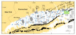
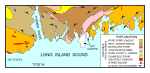
Bedrock that underlies southeastern Connecticut and, presumably, the survey area consists of Precambrian (?) and Paleozoic gneisses and granites of the Avalonian Terrane (Rodgers, 1985; fig. 2). Together, these rocks form an anticlinorium that is locally intruded by the Westerly Granite (Permian?), a fine-grained component of the Narragansett Pier Plutonic Suite (Rodgers, 1985; Hermes and others, 1994). Drill holes have encountered crystalline bedrock at about -86 m under Fishers Island (Fuller, 1905), and at -152 m under Orient Point on Long Island (Suter and others, 1949). The bedrock under eastern Long Island Sound and Block Island Sound was acoustically mapped, revealing a southward-dipping surface cut by south-southeast-trending bedrock valleys (Grim and others, 1970; McMaster and Ashraf, 1973; Needell and Lewis, 1984; Lewis and Needell, 1987). Coastal-plain sediments of Cretaceous age, consisting of unconsolidated to semi-consolidated gravels, sands, silts, and clays, have been reported on Block Island and along the north shore of Long Island (Fuller, 1914; Sirkin, 1976; Suter and others, 1949). McMaster and others (1968) identified a seaward-dipping, erosional remnant of the coastal-plain strata overlying bedrock unconformably in the southern portion of Block Island Sound. The cuesta formed by this remnant can be traced westward to Plum Island (Needell and Lewis, 1984). Although the cuesta scarp has been mapped well south of Fishers Island, Needell and Lewis (1984) inferred that some coastal-plain sediment extends under western Fishers Island, and Fuller (1905) interpreted blue clay resting on granite in a well on Fishers Island to be of Cretaceous age. In southeastern Connecticut and on the north shore of Long Island, bedrock and/or coastal-plain strata are unconformably overlain by two glacial drift sheets. The older of these sheets is commonly attributed to pre- to late Wisconsinan events, whereas the younger sheet is a product of the late Wisconsinan ice advance (Sirkin, 1982). Two late Wisconsinan end-moraine lines cross Long Island (Schafer and Hartshorn, 1965; Sirkin, 1982; Stone and Borns, 1986). The Ronkonkoma moraine, which marks the maximum extent of the late Wisconsinan glaciation, lies across central and southeastern Long Island, and extends eastward across the shelf in the direction of Block Island. To the north, a second moraine line (Harbor Hill-Roanoke Point-Charlestown) caps northern Long Island, Great Gull Island, and Fishers Island (fig. 1), and extends eastward across southern Rhode Island. As the ice sheet retreated, meltwater was dammed behind the moraines, and pro-glacial lakes formed in the areas presently occupied by Block Island Sound (Bertoni and others, 1977) and Long Island Sound (Lewis and Stone, 1991). During this time, coastal deltas prograded into the lakes, and thick deposits of fine-grained glaciolacustrine sediments accumulated on the lake bottoms (Lewis and DiGiacomo-Cohen, 2000). The depression cut into the Harbor Hill-Roanoke Point-Charlestown moraine that forms the Race is inferred to be the spillway for glacial Lake Connecticut (Stone and others, 2005). Less prominent recessional moraines lie between and to the north of the two major moraine belts on eastern Long Island and in southeastern Connecticut, and several of these have been mapped and described as double linear belts (Goldsmith, 1982; Sirkin, 1982; Stone and others, 2005). A consistent, late Wisconsinan-Holocene sequence of fluvial erosion (associated with the draining of the glacial lakes that occupied Long Island Sound and Block Island Sound), followed by a marine transgression and a subsequent transition to present-day conditions, has been proposed for the marine areas surrounding the Race (Needell and Lewis, 1984; Lewis and Stone, 1991). Circulation within Long Island Sound is tidally dominated. It is stronger in constricted areas such as the Race, where a large volume of water passes through a relatively narrow opening, and is weaker in broad, deeper basins (Signell and others, 2000). Scouring and redistribution of glacial and younger sediments by the strong tidal currents are common in eastern Long Island Sound and have also been observed in Block Island Sound (Needell and Lewis, 1984). These currents have a significant influence on surficial sediment distributions in eastern Long Island Sound and western Block Island Sound (Poppe and others, 1998, 2000). Although wind-driven and wave-produced currents are relatively important in shallow nearshore areas, especially during aperiodic storms when strong winds blow the length of Long Island Sound, fresher water entering the western sound creates a longitudinal salinity gradient that imparts a weak gravitational circulation (Signell and others, 2000). This circulation combines with the tidal forcing at the Race to produce a complex residual circulation, whose dominant feature is a series of sound-wide counterclockwise gyres (Welsh, 1993; fig. 1). Together, these gyres carry offshore water from Block Island Sound westward through the Race along the north shore of Long Island Sound, and brackish water from the western sound eastward along the southern shoreline. Modeling suggests that this combination of tidal and estuarine circulation is an effective sediment transport mechanism (Signell and others, 2000). |
Click on figures for larger images.
|