USGS Coastal and Marine Geology Program
Historical Shoreline Changes at Rincón, Puerto Rico, 1936-2006
|
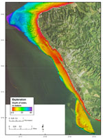
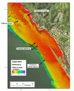
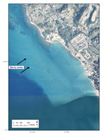
The SHOALS lidar bathymetry is shown in figure 12. The insular shelf off the study area shows a complex and variable bathymetry. From Punta Higüero to Punta Ensenada, the shelf is dominated by rocky outcrops and coral reefs. There are two shore-parallel troughs that begin about 1 km north of Punta Ensenada and extend to the southeast. These troughs terminate just south of Punta Ensenada. Figure 13 shows an apparent shoal feature located offshore of the small embayment formed between Punta Ensenada and a small point just south of Quebrada los Ramos. The lobate morphology at the southeastern tip, and the possible presence of surficial bedforms (fig. 13), suggests the feature may be at least partially composed of unconsolidated sediment. A 1997 orthophotograph of the study area obtained from the Centro de Recaudación de Ingresos Municipales (CRIM) of the Puerto Rico Office of Management and Budget has sufficient water clarity to permit identification of what appears to be sandy deposits on the shoal (fig. 14). The possible bedforms, however, also could be structurally controlled. That is, the morphology and internal structure of the shoal may be influenced substantially by the underlying geologic framework. It is unknown whether or how much of the shoal is comprised of unconsolidated sediment. The insular shelf between Quebrada los Ramos and Córcega is generally smooth and narrow, averaging about 500 m in width (fig. 12). Seaward of Punta Cadena, the shelf is about 1 km wide; a shelf-edge reef is present on the seaward margin. Data coverage in the nearshore zone is sparse; what data exist suggest that the rocky outcrops present on the beach in this area extend into the nearshore zone. |
Click on figures for larger images.
|