USGS Coastal and Marine Geology Program
Historical Shoreline Changes at Rincón, Puerto Rico, 1936-2006
|
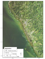
Historical shoreline positions spanning the period 1936-2006 were compiled using data from previous work (Thieler and Carlo, 1995), new shoreline positions digitized from georeferenced aerial photographs, and December 2005 and December 2006 GPS field surveys. A total of 14 shoreline positions were used for analysis (table 1). The 1950, 1963, 1971, 1974, 1977, 1987, and 1989 shorelines were produced by Thieler and Carlo (1995) using the Digital Shoreline Mapping System (Thieler and Danforth, 1994). The 1994, 2005, and 2006 shorelines were obtained by GPS field survey following methods described by Thieler and Carlo (1995). The 2004 shoreline was digitized from an orthophotograph supplied by the U.S. Army Corps of Engineers using ESRI ArcGIS software. The 1936 and 1983 shoreline positions were digitized using ESRI ArcGIS software from digital rectified aerial photograph mosaics produced by the U.S. Geological Survey Coastal Field Station at the University of Rhode Island. The Digital Shoreline Analysis System (DSAS) version 3.2 (Thieler and others, 2005) was used to construct shore-perpendicular transects along the shoreline from Punta Higüero to Punta Cadena (fig. 3). A nominal spacing of 50 m between transects was used. The DSAS computes shoreline change using several different methods: (1) simple linear regression (2) weighted least squares regression, (3) least median of squares regression, and (4) endpoint rate. These and other methods of estimating shoreline change are described by Genz and others (2007). The standard error, correlation coefficient, and confidence interval also were computed for the simple and weighted least squares methods. A 95-percent confidence interval was selected to express the uncertainty associated with the rate of change statistics. A SHOALS lidar bathymetry survey (see http://shoals.sam.usace.army.mil for information) was conducted in the study area during 2001. These data were obtained from the USGS lidar data repository in St. Petersburg, Florida. The lidar data were supplied as binned data with a horizontal resolution of 7.6 m. The nominal vertical accuracy of the data is 30 cm. The SHOALS data were gridded and visualized using IVS 3D Fledermaus software. |
Click on figures for larger images.
|