
Woods Hole Science Center
Sea-Floor Character and Sedimentary Processes of Great Round Shoal Channel, Offshore Massachusetts
![]() Title |
Introduction |
Setting |
Methods |
Overview |
Discussion |
Interpretation |
Data Catalog |
Acknowledgments |
References |
Figures |
Bottom Photographs |
Sediment Data |
Contacts
Title |
Introduction |
Setting |
Methods |
Overview |
Discussion |
Interpretation |
Data Catalog |
Acknowledgments |
References |
Figures |
Bottom Photographs |
Sediment Data |
Contacts
 |
||
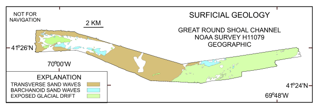
Figure 41. Interpretation of the DTM and sidescan-sonar mosaic from NOAA survey H11079 of Great Round Shoal Channel. Shown are the areas characterized by exposed glacial drift, transverse sand waves, and barchanoid sand waves. White areas within the study area are primarily relatively flat and megarippled reworked Holocene sand. | ||


