
Woods Hole Science Center
Sidescan-Sonar Imagery, Multibeam Bathymetry, and Surficial Geologic Interpretations of the Sea Floor in Rhode Island Sound, off Sakonnet Point, Rhode Island
![]() Title |
Introduction |
Geologic Setting |
Data Acquisition/Processing |
Bathymetry |
Sidescan-Sonar Imagery |
Environments |
Discussion |
Summary |
GIS Data Catalog |
Acknowledgments |
References |
Figures |
Contacts
Title |
Introduction |
Geologic Setting |
Data Acquisition/Processing |
Bathymetry |
Sidescan-Sonar Imagery |
Environments |
Discussion |
Summary |
GIS Data Catalog |
Acknowledgments |
References |
Figures |
Contacts
 |
||
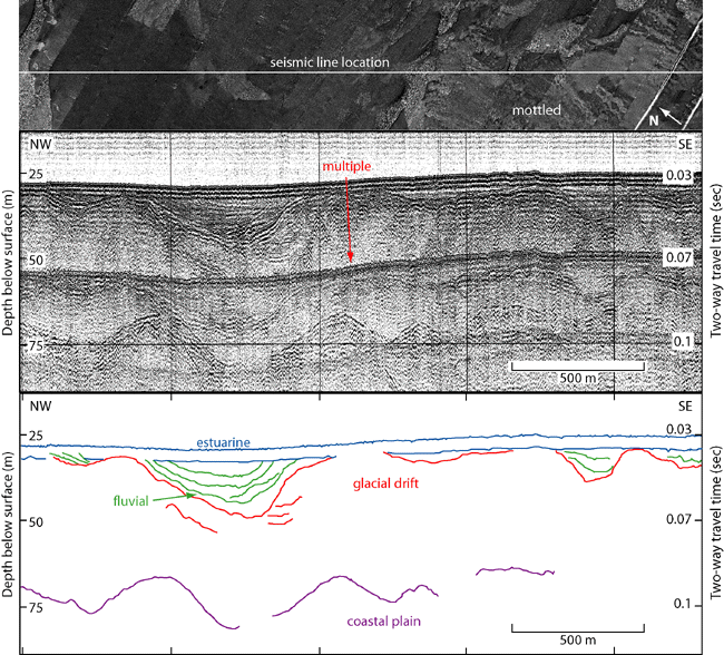
Figure 12. Sidescan-sonar imagery and Boomer seismic reflection profile (O'Hara and Oldale, 1980) and interpretation through an area of mottled backscatter. Right side of sidescan-sonar image shows mottled backscatter (top image). Seismic profile shows Cretaceous coastal plain sediments overlain by Wisconsin glacial drift and Holocene fluvial and estuarine sediments. Mottling tends to occur in areas where glacial moraine sediments are either exposed or near the surface. Vertical exaggeration: 13X. Depths are based on the assumed compressional wave velocity of 1500 m/s. Location of seismic line shown in figure 2 . | ||

