
Woods Hole Science Center
![]() Title |
Introduction |
Setting |
Methods |
Results |
Discussion |
Data Catalog |
Acknowledgments |
References |
Figures |
Contacts
Title |
Introduction |
Setting |
Methods |
Results |
Discussion |
Data Catalog |
Acknowledgments |
References |
Figures |
Contacts
 |
||
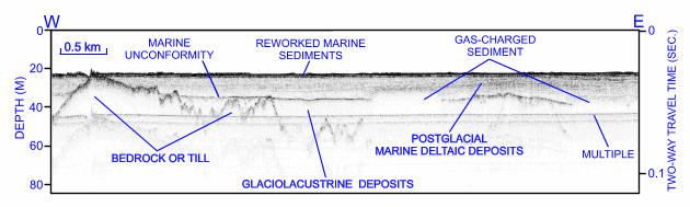
Figure 21. CHIRP high-resolution seismic-reflection profile from the western part of survey H11252 showing irregular character of till and (or) bedrock surface west of Six Mile Reef. Note thin nature of the modern sediments, smooth nature of the sea floor, location of marine unconformity, and postglacial marine deltaic deposits that dip slightly westward. Location of seismic profile is shown in figure 16. | ||


