
Woods Hole Science Center
![]() Title |
Introduction |
Setting |
Methods |
Results |
Discussion |
Data Catalog |
Acknowledgments |
References |
Figures |
Contacts
Title |
Introduction |
Setting |
Methods |
Results |
Discussion |
Data Catalog |
Acknowledgments |
References |
Figures |
Contacts
 |
||
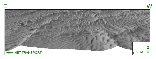
Figure 33. Perspective view of sand waves north of western part of shoal. Arrow shows interpreted net transport direction. Brackets show lateral and vertical scale, but are only accurate in the foreground. Location of perspective view is shown in figure 15; scale is valid only in foreground. | ||


