Woods Hole Science Center
Sidescan-Sonar Imagery and Surficial Geologic Interpretations of the Sea Floor in Central Rhode Island Sound
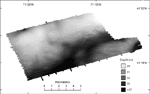
A broad, low ridge extends across the northern and western parts of the study area and a central channel stretches southwestward between the ridge and another bathymetric high to the southeast (fig. 6). Water depth increases to the north of the ridge, along the northern edge of the study area. The ridge crest lies in water depths of about 30 m and is cut by both northward and southward trending channels. The central channel is as much as 39 m deep and has a small central bathymetric high about 34 m deep. The bathymetric high in the southeast part of the study area is about 31 m deep. There is a bathymetric low in the southeastern corner of the study area. The sea floor in the channel and bathymetric low tends to be relatively smooth, whereas the sea floor on the ridge and the other bathymetric high tends to have bed forms. |